The purpose of the Wilket Creek Rehabilitation Project is to protect public infrastructure and mitigate erosion and flooding while enhancing Wilket Creek’s ecosystem.
The project follows a long-term rehabilitation plan focused on enhancing channel stability and ecological integrity of the system in an economical and sustainable manner and in accordance with the Municipal Class Environmental Assessment process.
Project Map
Zoom in and click on the coloured lines on the map to see reaches and project details.
Learn More About the Project


Master Plan
In accordance with the Environmental Assessment Act, the Wilket Creek Channel within Wilket Creek Park Rehabilitation Study to Address Erosion Hazards Threatening Infrastructure and Wilket Creek Geomorphic Systems Master Plan (hereon in referred to as the Master Plan) was completed as a Municipal Class Environmental Assessment (MCEA), the prescribed process for projects of this nature.
Toronto and Region Conservation Authority (TRCA) on behalf of the City of Toronto, completed the study to assess the geomorphic systems of the Wilket Creek subwatershed in order to develop a long-term strategy to address erosion hazards to municipal lands and infrastructure.
Between 2011 and 2015, emergency repairs at the three critical sites within Wilket Creek Park were carried out to safeguard municipal infrastructure while the overall strategy was being developed. The Master Plan was completed in March of 2015.
Planning Mechanism for the Undertaking
The project followed the planning and design process prescribed in the MCEA for Schedule “B” projects. The intent was to develop a Master Plan for long-term remediation of the entire watercourse.
The Class EA requirements for the development of a Master Plan are as follows:
- Phase 1: Definition of the Problem(s);
- Phase 2: Identification and Assessment of Alternative Solutions;
These phases identify the potential negative and positive effects of the implementation of the project and review a number of solutions. TRCA documented the decision making process and the value judgments made in selecting the best solution.
A detailed Master Plan report was developed upon completion of the study; the report includes all background information, technical analyses, community involvement, a list of the solutions and the analysis of each.
The Master Plan was available for review and comments for a thirty-day period from February 19, 2015 to March 21, 2015 and remains in two libraries permanently for public review. These libraries are; The Locke Library at 3083 Yonge Street and the North York Civic Center at 5120 Yonge Street.
The report is also available for download in sections at the bottom of this page.
The MCEA process prescribes that all views be taken into consideration during the planning and design phases of the project.
A comprehensive contact list was comprised of concerned citizens, local interest groups, government agencies and non-governmental organizations. These groups received project information and provided comment as the project progressed.
Public Information Centres were held to provide detailed information regarding the study, obtain feedback on the evaluation of alternative options and the development of long-term remedial measures, address any concerns and recommend long-term solutions prior to finalizing the study.
Public Notices
- Notice of Study Commencement and PIC
- Notice of Public Meeting June 2011 – North York Mirror
- Notice of Public Meeting PIC #3 – February 2014
- Notice of Public Meeting June 2014 – Advertisement
- Notice of Public Meeting June 2014 – Park Signage
- Notice of Study Completion
- Wilket Creek Rehabilitation Project Information Leaflet
- Notice of Construction- Emergency Works Phase I
- Notice of Construction- Emergency Works Phase II
Public Information Meetings
- Public Information Centre 1 – June 29, 2011
- Public Information Centre 2 – December 18, 2013
- Public Information Centre 3 – February 25, 2014
- Note: The February 25, 2014 presentation, PIC 3 was a repeat of the December presentation due to the poor turn out at that meeting.
- Public Information Centre 4 – June 5, 2014
Master Plan Documents
- Executive Summary
- Table of Contents
- Study Report
- Appendix A – Archaeology Report
- Appendix B – Hydraulic Analysis
- Appendix C – Ecological Classification Tables
- Appendix D – Evaluation of Alternatives
- Appendix E – Consultation Records
- Appendix F – Aboriginal Consultation
- Appendix G & H – Cost Estimate & Detailed Designs
Project Background
The Wilket Creek subwatershed of the Don River
Wilket Creek is a second order tributary to the West Don River, it has a drainage area of 15.5 km2.
The northern portion of the channel south to York Mills Road was turned into a series of piped systems during the area’s development in the 1940s and 1950s.
South of York Mills Road the creek is an open channel for approximately 4.5 km, ending at its confluence with the West Don River.
About 80% of the Don River watershed is urbanized and 100% of the Wilket Creek subwatershed is urbanized. The southern portion of Wilket Creek is one of the few remaining open channel tributaries in the Don River catchment area.
Of the remaining open flow tributaries; Wilket Creek, Taylor Massey Creek and Burke Brook have sustained some of the longest and most dramatic hydrological changes due to urbanization in all of Southern Ontario.
Creeks under Stress
Wilket Creek has no major tributaries; it receives water from overland flow, drainage pipes, storm sewers and some ground water.
The buried catchment area north of York Mills Road to Steeles is old and densely urbanized with few to no natural or stormwater management controls. As such, flows in the creek rise and fall rapidly following precipitation.
This “flashy” nature of the watercourse results in destabilizing the natural system through excessive erosion. In order for the system to balance itself, rapid and precarious adjustments to the creek accommodate for the increased flows.
Destabilizing adjustments to the watercourse can include:
- increased cross sectional area of the channel
- down-cutting into the channel bed
- increased sediment loads due to the erosion
- changes to typical channel characteristics such as meandering patterns
- decreased quality and quantity of habitat
- degraded water quality
- loss of riparian vegetation (MOE, 2003)
Wilket Creek is experiencing all of the above types of watercourse degradation.
Erosion in Wilket Creek
Because of its rapid degradation a number of erosion control measures have been implemented in Wilket Creek over the years. Primarily, old fashioned, conventional engineering controls like hardened (concrete) beds and banks, rip rap, gabion baskets and armour stone have been used.
These structures often exacerbate erosion downstream or around the structure itself. Additionally, the ecologic integrity of the system has suffered, severely degrading aquatic and riparian habitat in eroded areas.
In the late 1950s the North York sanitary trunk sewer system was built within the Wilket Creek valley, crossing under the watercourse in several locations along its length. Where the watercourse and sanitary lines intersected, the pipe was encased in concrete.
As result of creek destabilization there are multiple sites where the encasement was exposed, one site where the concrete has been eroded exposing the pipe, and a few locations where the pipe is exposed due to migration of the watercourse.

Other erosion hazards exist within the subwatershed including; degraded public walking paths, under-sized and degraded pedestrian bridges, outflanked manhole chimneys and increased riparian-tree hazards.
Mitigating these hazards and preventing future hazards and further ecological degradation are the primary reasons for the ongoing work within the Park.
History of the Wilket Creek Rehabilitation Project
The Wilket Creek tributary of the West Don River was one of the watercourses that suffered a significant amount of damage as a result of the August 19, 2005 severe weather event. The City of Toronto retained TRCA in 2007 to manage, design and implement large-scale restoration works within Edwards Gardens and to complete 10 repair projects focused on infrastructure protection and public safety.
Shortly following completion of the Edwards Gardens restoration work, another severe storm event hit the Toronto area on June 23, 2008, damaging three of the sites recently repaired. It was evident by this point that a comprehensive study and rehabilitation plan was required to provide long-term protection for municipal infrastructure and public safety within Wilket Creek Park.

In 2009, Toronto Parks, Forestry & Recreation (PF&R) and Toronto Water identified multi-year funding commencing in 2010 for the completion of a Master Plan MCEA. TRCAs role was to manage the project on the City’s behalf, including the implementation of any works recommended.
Following an initial assessment by Parish Geomorphic, the consulting firm was retained by TRCA to assist with the study and design components of the project.
Three areas within Wilket Creek Park were identified as requiring immediate attention due to the risk to municipal infrastructure and/or public safety. These sites are referred to as Site 3, Site 6 and Site 7 in the Master Plan.
Given the anticipated length of time required to complete the study phase, the repair of Sites 3, 6 and 7 were recommended to be expedited as emergency works, with the understanding that the designs for these sites would be in alignment with the overall strategy in the Master Plan.
Because of the scale of the proposed work, the emergency works were broken up into a number of phases to be undertaken within a 5 year plan. Emergency works repairs were completed in December of 2015.
Past Project Phases
July 2019 (Reach 2 Construction)
The restoration work within Wilket Creek Park along Reach 2 is now complete. The trail within the work area was repaved in July and the park has been reopened for public use.
The soil stockpile near the main entrance of Wilket Creek Park and Sunnybrook Park will be removed this season. Some fencing within the park may still be present to allow the newly planted vegetation and grass time to firmly establish.

June 2019 (Reach 2 Construction)
The stockpiled soil within the work area has now been cleared, and construction staff have been able to continue restoration efforts in this area. The trail base is now complete, and restoration tree and shrub plantings have been added throughout the site.
Currently the trail remains closed during the weekdays while staff are on site and open on weekends and holidays.
Asphalt paving of the trail is scheduled to be completed in July, which will result in a temporary trail closure of approximately one week while staff are on site with large equipment and machinery. Once paving is complete, the trail will be fully reopened to the public. Some fencing may still be present to allow the newly planted vegetation time to firmly establish.
The trail will be open when construction staff are not on site, however path users should proceed with caution as there will be no trail maintenance in the area and uneven surfaces may be present. Unfinished path surfaces may cause some uneven sections, and wet conditions may result in muddy areas.
During this time the alternative routes provided on the Trail Closure Information Map can still be accessed. For previous updates, please see Past Project Phases.


May 2019 (Reach 2 Construction)
Construction staff have been continuing to prepare the newly realigned trail for paving; this includes implementing the final trail realignment, grading the trail to the appropriate elevation, and widening the existing path for trail users. The stockpiled soil material is scheduled for removal this month, with asphalt paving and restoration to continue into June.
Currently the trail remains closed during the weekdays and open on weekends and holidays while construction staff are not on site. Trail users should notice a gradual improvement to the existing temporary trail as staff continue to work on the new trail realignment and conditions begin to dry with the onset of warmer weather.
The trail in this area will remain closed on weekdays while heavy equipment is present to ensure public safety is maintained when the work is underway.
The trail will be open on weekends, however path users should proceed with caution as there will be no trail maintenance in the area and uneven surfaces may be present. Continuing trail realignment may cause some disjointed connections between completed work and the existing path, and wet spring conditions may result in muddy areas.
During this time the alternative routes provided on the Trail Closure Information Map can still be accessed.
Please review the Notice of Construction Sign and Trail Closure Information Map for additional information regarding the scope of the project, anticipated timelines, and impacts. For previous updates, please see Past Project Phases.


April 2019 (Reach 2 Construction)
As TRCA staff have completed the extensive in-water portion of the work along Reach 2, they are continuing to focus on the trail realignment portion of the designs and general restoration activities. The stockpiled soil material in the southern parking lot is scheduled for removal this spring, and the parking lot will then be reopened for public use.
Once the soil is removed from the project site, staff will be able to partially restore this portion of the park which should improve current trail conditions and reduce the amount of mud during weekend trail openings. The trail is anticipated to be repaved before the beginning of summer, but a temporary gravel path will be fully open to the public as soon as the construction site is no longer active.
Restoration planting activities are scheduled to occur in June, however this is not anticipated to cause substantial disturbance to trail users.
March 2019 (Reach 2 Construction)
TRCA staff have completed the major in-water portion of the work along Reach 2, and are continuing to focus on the trail realignment portion of the designs. The stockpiled soil material in the southern parking lot will then be removed and the parking lot will be reopened for public use.
The trail realignment is important to reduce flooding and erosion caused by Wilket Creek, in order to allow for improved public use of the trail system. The trail is anticipated to be repaved before summer 2019, but the existing gravel path will be fully open to the public once the construction site is no longer active.
The trail in this area will currently remain closed on weekdays while heavy equipment is present to ensure public safety is maintained when the work is underway. Final restoration is anticipated to occur in late spring 2019.
The trail will be open on weekends, however path users should proceed with caution as there will be no winter maintenance in the area and uneven surfaces may be present. Continuing trail realignment may cause some disjointed connections between completed work and the existing path.
February 2019 (Reach 2 Construction)

TRCA staff have completed the major in-water portion of the work along Reach 2, and are now focusing on the trail realignment portion of the designs.
This trail realignment will allow for reduced flooding along the park path by increasing the elevation of the path from its original position. Path erosion will also be reduced by moving the path slightly further away from the creek in strategic places. Once complete, this work will allow for a more robust trail system with decreased potential for pooling water.
The trail in this area will remain closed on weekdays while heavy equipment is present to ensure public safety is maintained when the work is underway. Work is anticipated to continue in March with final restoration to occur in late spring 2019.
The trail will be open on weekends, however path users should proceed with caution as there will be no winter maintenance in the area and uneven surfaces may be present. Continuing trail realignment may cause some disjointed connections between completed work and the existing path.
January 2019 (Reach 2 Construction)
TRCA staff returned to Wilket Creek Park in January to continue the rehabilitation works along the creek. The pool and riffle system are continuing to be constructed along this section of the creek to provide erosion control, habitat for aquatic species, and protection to municipal infrastructure.
The trail in this area will remain closed on weekdays while heavy equipment is present to ensure public safety is maintained when the work is underway.
The trail will be open on weekends, however path users should proceed with caution as there will be no winter maintenance in the area and uneven surfaces may be present.
December 2018 (Reach 2 Construction)
Construction staff at Wilket Creek Park are preparing the construction site for a temporary shutdown during the winter holidays.
The park path will be temporarily reopened from December 20, 2018 until January 1, 2019, and on weekends beginning on January 5, 2019.
The trail closure will resume on weekdays starting on January 2, 2019 while heavy equipment is present to ensure public safety is maintained when the work is underway.
During the temporary trail openings path users should proceed with caution as there will be no winter maintenance in the area and uneven surfaces may be present.
During this time the alternative routes provided on the Trail Closure Information Map can still be accessed.
Please review the Notice of Construction Sign and Trail Closure Information Map for additional information regarding the scope of the project, anticipated timelines, and impacts. For previous updates, please see Past Project Phases.
November 2018 (Reach 2 Construction)
Construction staff at the Wilket Creek Restoration Project site are currently working along the bed of Wilket Creek, creating stretches of pools and riffles. Soon staff will be redirecting their attention to the banks of the creek in this area, regrading them to create a more gradual turn in Wilket Creek, reducing the erosive forces on the bank and effectively protecting nearby sanitary sewer infrastructure from potential damage.
In addition to the works along the creek, construction crews anticipate some park path realignment in this area. The park path will be realigned to prevent damage to public infrastructure and increase public safety in the area, as water levels at Wilket Creek are known to quickly rise and flows quickly increase during rain events.
On-site, the by-pass pumping system is working to divert water around the current work area in the creek. Construction staff are consistently maintaining the by-pass pumping equipment to ensure it is working as efficiently as possible.
The frequent rain and storm events experienced this fall along Wilket Creek have caused major flow and water level increases. As staff are currently working in the channel, these rain events result in necessary additional maintenance and reestablishment of the isolated work areas to ensure safe working conditions.
Due to the delays associated with these frequent rain events, the works along Wilket Creek are now expected to be complete in February 2019. Final restoration of the area is still planned for spring 2019, as weather permits.

October 2018 (Reach 2 Construction)
TRCA’s construction staff are continuing restoration works along Wilket Creek and within the park. They are currently working on the creation of pool and riffle sequences along the channel. The riffles provide grade control along the creek and the pools consist of slower and deeper water, which is the preferred habitat for some aquatic species. Vegetated buttresses are also being constructed to provide the creek banks with protection from Wilket Creek’s erosive forces. Protecting the creek banks from erosion will also protect the adjacent public trail.
A new pedestrian bridge has been installed within the project area to provide park users with the ability to safely cross the creek following the completion of the restoration works.
September 2018 (Reach 2 Construction)
Construction staff are continuing their work as scheduled along the creek within Wilket Creek Park. Work completed thus far includes the creation of pools along the channel bed as well as vegetated buttresses along the creek banks. The work is being implemented starting from the upstream limit of the project area and will continue downstream, with similar installations taking place to fortify and rehabilitate Wilket Creek in the long term.
Our construction crews are continuing to use by-pass pumping to divert water around the sections of the creek that staff plan to work in.
Please review the Notice of Construction Sign and Trail Closure Information Map for additional information regarding the scope of the project, anticipated timelines, and impacts. For previous updates, please see Past Project Phases.
August 2018 (Reach 2 Construction)
The work within Wilket Creek Park is continuing as scheduled. Construction staff are completing their site set-up, which includes building an access road for heavy equipment, vegetation removal as needed, and setting up erosion and sediment control measures. Many trees will be planted within the project site and surrounding areas once the project is complete to compensate for the necessary tree removals. Tree protection fencing has been added around the trees that are not to be impacted during construction to ensure they are preserved.
By-pass pumps have been installed to divert water around the sections of the creek that staff plan to work in along the channel. The construction of the erosion control structures along the channel bed and creek banks will now begin.
June 2018 (Reach 2 Construction)
Notice of Project Commencement for Wilket Creek Reach 2 (Phase 2)
Construction within the first phase of Wilket Creek Reach 2 is now complete, and construction staff are now preparing to begin the second phase of the work. This phase will complete all currently planned construction activities for the Wilket Creek Rehabilitation Project within Wilket Creek Park. Work is anticipated to be completed by December 2018, with restoration of the path and tree plantings to follow as weather permits. Please review the Notice of Construction Sign and Trail Closure Information Map for additional information.
Reach 1
Reach 1 Channel Improvements (Formerly Phase IV Emergency Works)
Reach 1 extends from the confluence of Wilket Creek with the West Don River upstream to the most southerly pedestrian bridge. The 480 metres (m) of watercourse that make up Reach 1 is broken up into three work sites: Site 1, Site 2 and Site 3 Phase 2.
For the past 2 years, TRCA and City of Toronto have been working within Reach 1 to protect sanitary and park infrastructure which was at risk due to erosion. The emergency works involved widening and re-aligning the creek to allow for greater flow capacity; bank and bed protection which will stabilize the creek and mitigate the erosive forces that are considered hazardous to Wilket Creek’s ecological integrity. Trail improvements were completed in the spring of 2016 and included raising the path elevation to decrease path flooding.
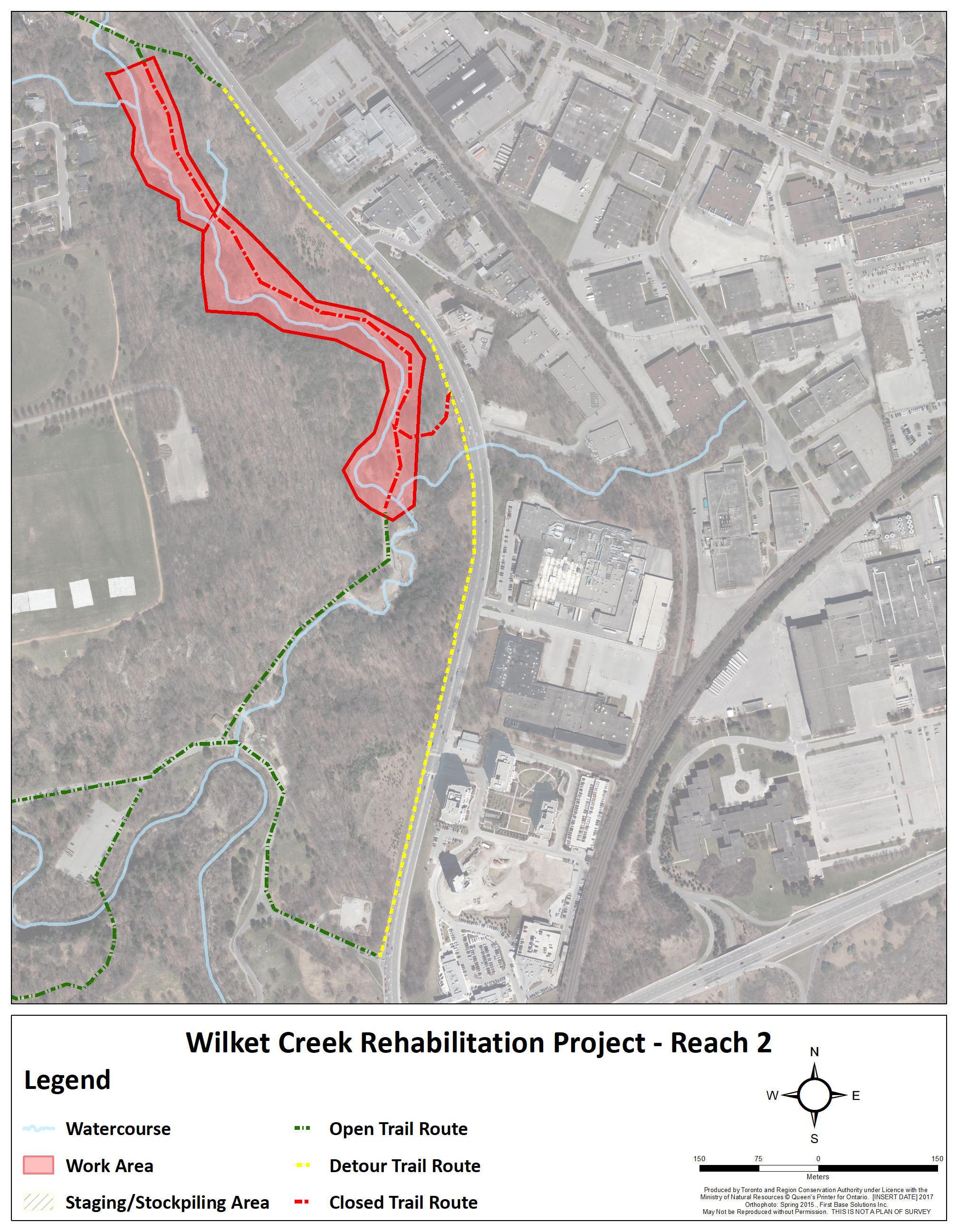
Reach 2
Reach 2 Channel Improvements
Reach 2 starts at the most southerly bridge in Wilket Creek Park and extends upstream 858 metres (m) to near the north park entrance from Leslie Street. The Reach is broken up into hazard areas known as: Site 3 Phase 1 (completed, formerly Phase III Emergency Works) and Site 4, Site 5 and Site 6 Phase 2.
Site 3 Phase 1 work was completed in 2013 and included the installation of a new 30 m pedestrian bridge, channel widening and re-alignment to move the watercourse away from the steep valley wall.
The remaining sites were all considered under the overarching Reach 2 detailed designs, which were developed for this entire portion of the creek. The designs were divided into two phases for construction and were completed in 2019.
Reach 3
Reach 3 Channel Improvements (Formerly Phase I & II Emergency Works)
Reach 3 begins near the northern park entrance off Leslie Street extending upstream 640 metres (m) to the southern limit of Edwards Gardens. The reach contains Sites 6 Phase 1, Site 7 and Site 8. Emergency works were completed in Sites 6 Phase 1 and Site 7 in 2011 to 2012 to repair erosion hazards to the sanitary infrastructure. At this time, channel improvements were implemented to widen and re-align the creek away from the eroding valley walls. A 30 m pedestrian bridge replaced an undersized and degraded wood bridge and a 60 m concrete boardwalk was added to allow for the natural re-generation of a wetland area.
Reach 4
Reach 4 Restoration Works
A number of improvements were completed in Edwards Gardens in 2006-2007 to repair areas degraded by the storm events of 2005 and 2006.
Repair work within the reach included; channel widening and stabilization, bridge replacements and park path improvements.
Proposed long-term improvements were recommended in the Master Plan and include; sanitary sewer protection, removal of weirs which act as fish barriers, further channel widening in constrained areas. The long-term improvements will also seek to replace existing gabion baskets (wire baskets filled with stone which rust and degrade over time) with bioengineered bank stabilization, which uses a combination of engineering and specially selected vegetation to help stabilize the bank.
Current Project Phases
TRCA is currently working on the detailed design phase for the remainder of Reach 3. This project aims to protect vital municipal infrastructure, including sanitary sewers and maintenance holes, while enhancing public safety.
Once the detailed designs are completed, and all necessary permits and approvals are in place, construction is expected to begin in 2027+.
Future Project Phases
This section will be updated as sites within the project area are identified for future planning activities.
Contact Us
Sarnia Vijayakumar
Erosion Risk Management
Restoration & Infrastructure
sarnia.vijayakumar@trca.ca