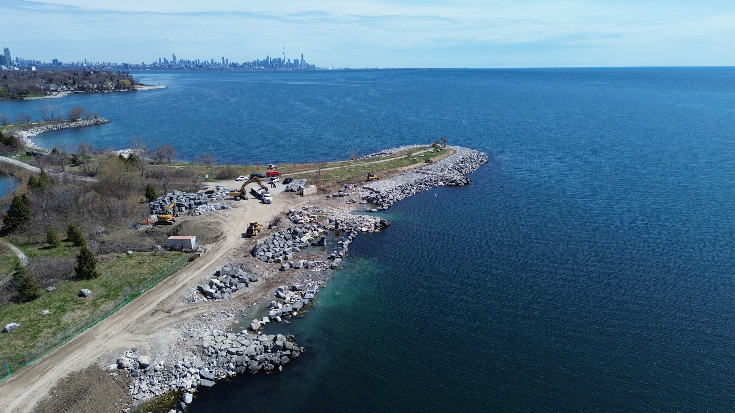
Toronto and Region Conservation Authority (TRCA) is conducting major maintenance repairs in Colonel Samuel Smith Park on areas of the shoreline damaged by erosion.
TRCA will address current erosion hazards in the park and improve protection around the shoreline.
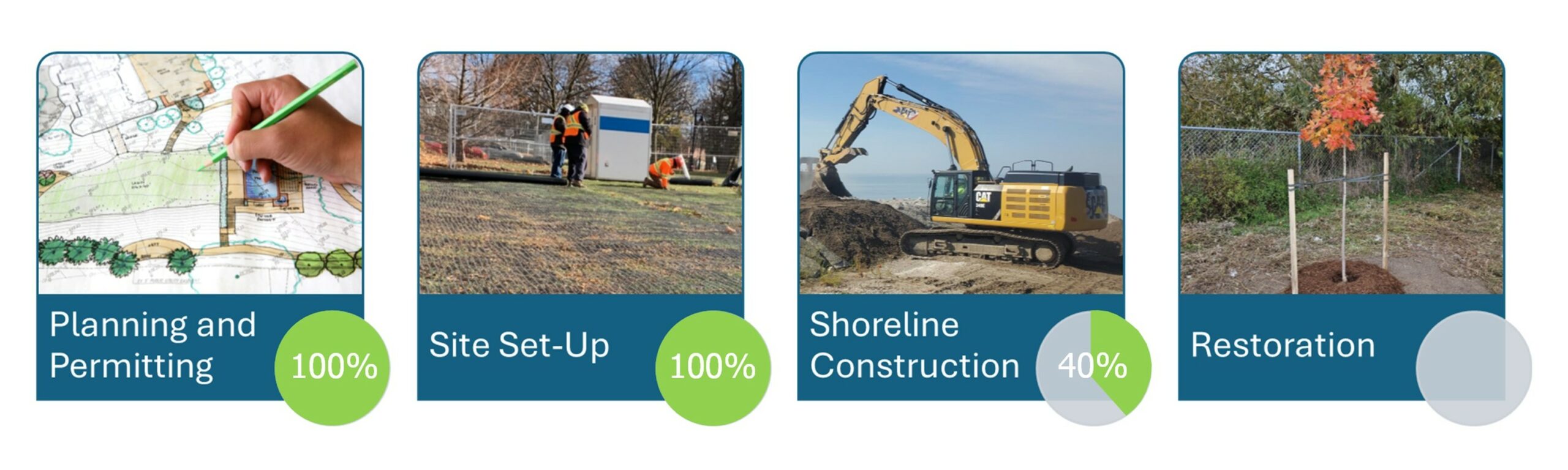
PROGRESS SNAPSHOT – April 2026
Please Be Kind to Our Fence Panels
and Help Keep Everyone Safe
Did you know that there are more than 800 individual fence panels being used at Colonel Samuel Smith Park?
These fence panels play an important role in keeping people safe from construction equipment, uneven surfaces, and loose construction materials. Removing, pushing over, or otherwise vandalizing these fence panels can result in:
- Safety hazards for anyone entering the work site
- Extra time for staff to repair and re-install fence panels, which means longer trail closures
- Delay in truck deliveries while fence panels are secured
- Increased chance of wildlife (e.g. turtles) entering the work site near wetland habitat
- Injury to nearby trees and other vegetation
Please use only the designated detour routes to access the park and obey all site signage. This is for your safety, the safety of our construction staff, and to help protect local wildlife during construction.
For more information, see the Access Map and other access information below.
LEARN MORE:
Frequently Asked Questions and Construction Access
View our list of project FAQs
View our Construction Access Planning Summary 2024
LEARN MORE ABOUT THE PROJECT


Project Background
Colonel Samuel Smith Park is a popular waterfront park that offers visitors ample recreational opportunities alongside dynamic wildlife habitats. The waterfront extension of the park was built in the 1980s and includes popular shoreline trails for lake access.
Over half of the structures TRCA monitors which protect the shoreline in Colonel Samuel Smith Park are badly damaged and a high priority to repair. The photos below show the damage caused by waves and storms along the Phase 1 shoreline, creating a hazard to park visitors and eroding parkland.
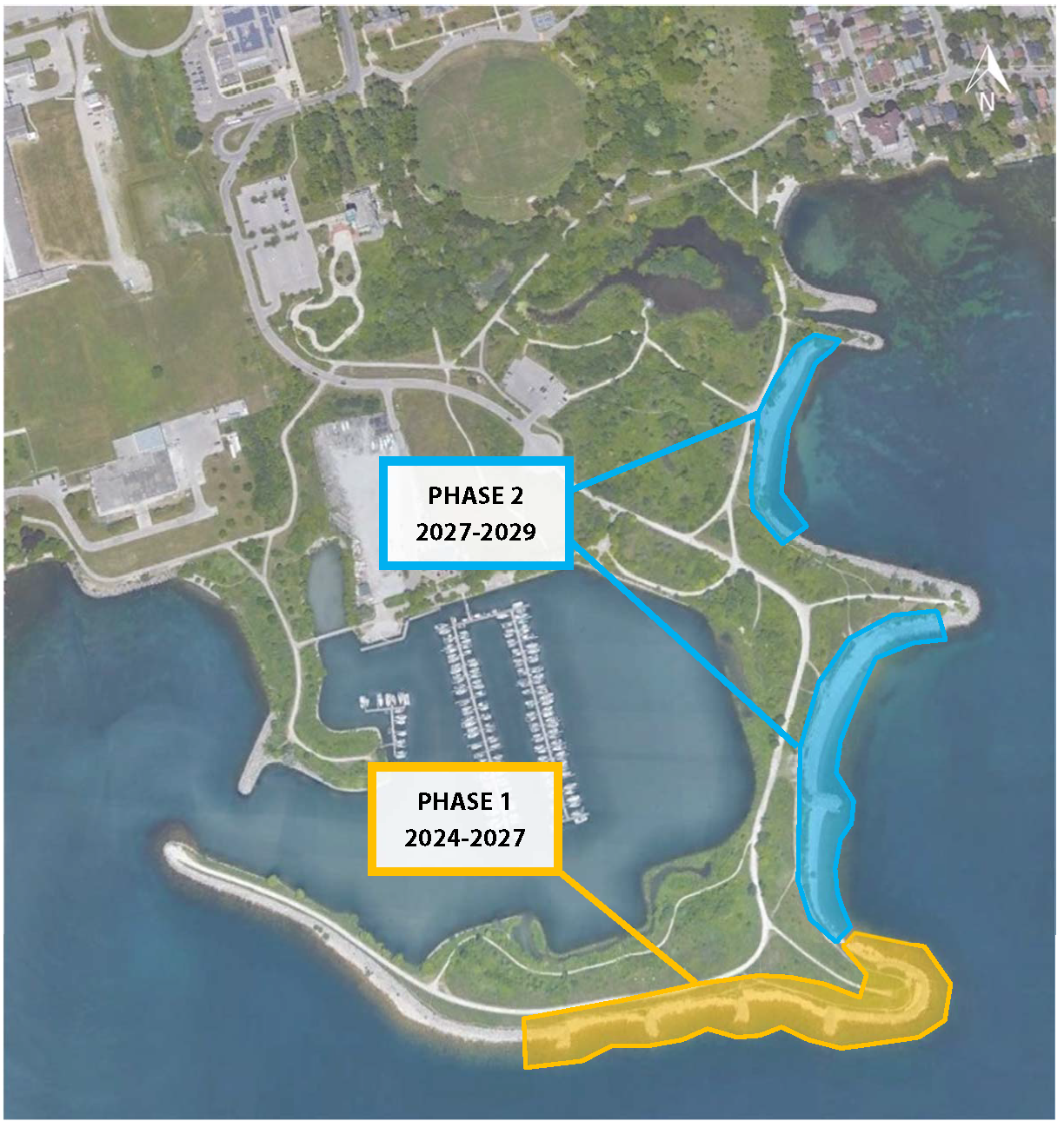
TRCA is phasing construction work to ensure areas that pose the most immediate potential hazard to park visitors are repaired first, while also considering and accommodating migratory bird movement and wildlife communities.
Phase 1 began in late 2024; Phase 2 planning will start in 2025 and begin following Phase 1 anticipated completion in 2027.
Project Location
Colonel Samuel Smith Park is located at 3145 Lakeshore Boulevard West in Etobicoke. Close to or within park boundaries are Humber College buildings, Lakeshore Yacht Club, two schools and a regional arts centre.
The park itself also includes several amenities such as a seasonal ice rink, off-leash dog park, the Powerhouse Rec Centre, and trails that extend along the man-made peninsula.
Events are held year-round in the park and attract many visitors from the local community and beyond. The area is a migration stopover point and nesting location for many birds and is part of the City of Toronto’s Spring Bird Festival.
Construction work will be scheduled to accommodate these events for park users.
Project planning has incorporated feedback received during: previous work in the area, public drop-in information sessions, meetings with the City of Toronto and surrounding organizations during the design and access planning process in order to accommodate the high activity level within the park.
Access
In order to access the project area, construction teams will have to utilize existing park trails.
The result of discussions on the best routes and times to close trails for safe access determined that the best route was from the Gatehouse Laneway, connecting to the southernmost trail via the paved pedestrian trail.
However, TRCA, City of Toronto, and community groups understand how important access to these trails is for park users. In order to best accommodate movement throughout the park while maintaining a safe access route, construction teams will implement a number of protection measures for trees and wildlife, as well as open the access route outside work hours (7:00 a.m. to 4:00 p.m., Monday to Friday).
Access to all or part of the project area and access route will be open outside work hours (7:00 a.m. to 4:00 p.m.) and on weekends. See the map below for details on the access route.

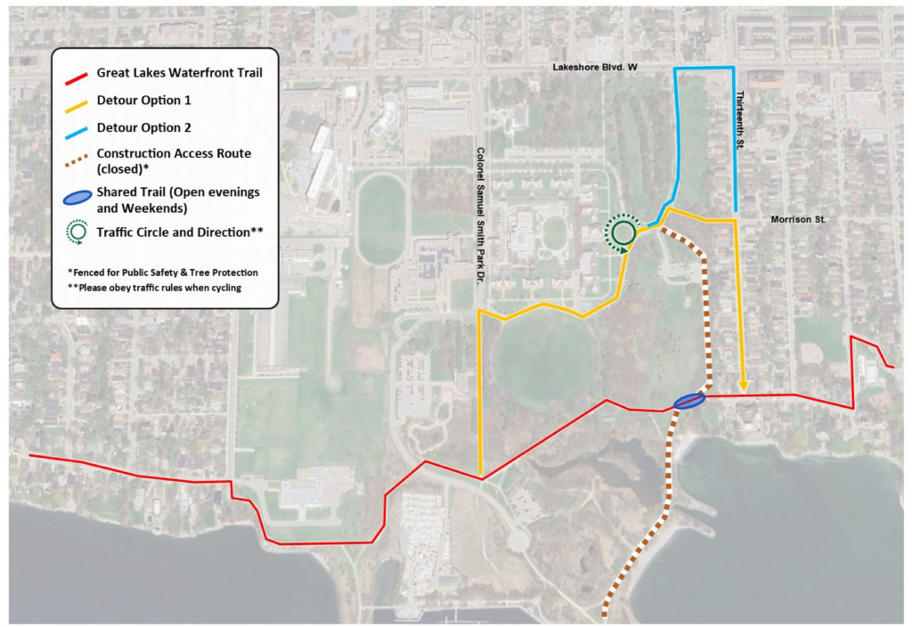
Parts of the trail that will remain closed, be shared with the public, and open to allow access on evenings and weekends are also highlighted in Figure 6.
Extra steps will be taken by teams during Phase 1 access work to protect the wetland and aquatic species from negative impacts.
Information signs are placed at applicable park entrances and affected trail routes to help cyclists and pedestrians navigate construction closures. Notice of Project Commencement letters were also circulated to members of the local community prior to construction. See our detour and trail access maps above.
Detour routes that ensure public safety around construction equipment and activities while maintaining access to the park will be marked so park users and commuters can continue to enter via Thirteenth Street.
Phase 1 construction started in late 2024.
Previous Projects and Studies
TRCA completed numerous studies of Colonel Samuel Smith Park as part of previous project works and ongoing habitat monitoring.
A baseline inventory was completed for the project area in 2021 to compile all the available information on the site.
This inventory included species at risk screenings, mapping and historical data accrued through previous projects, flora and fauna inventories, and fish surveys to identify species present and their spawning activity in the area.
These studies were used in developing and selecting preferred designs for the park.
Additionally, TRCA obtained underwater mapping surveys in 2022 during the design process to understand the unique shoreline qualities of the project area more fully, shown in the map below.
This kind of survey, called Multibeam Echo Sounding (MBES), was the first of its kind procured by TRCA for shoreline maintenance.

TRCA continues to work with teams within the organization as well as community stakeholders during the design, development, and implementation planning process.
Habitat
Colonel Samuel Smith Park provides habitat for many plant and animal species, including bird, insect, and reptile species at risk.
It is a popular site for photographers and nature enthusiasts, including community groups that monitor plant and animal species in the park.

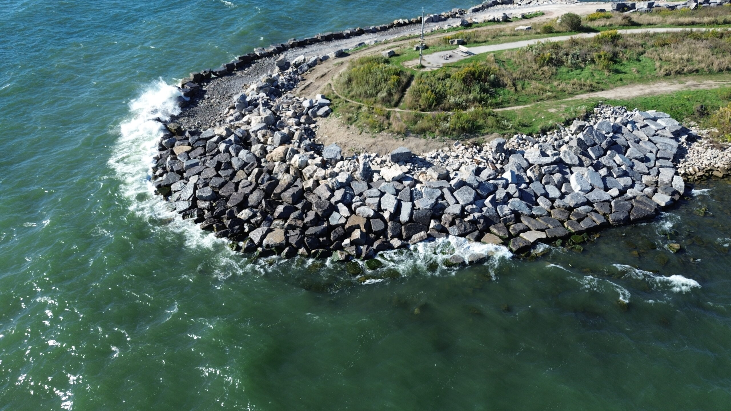
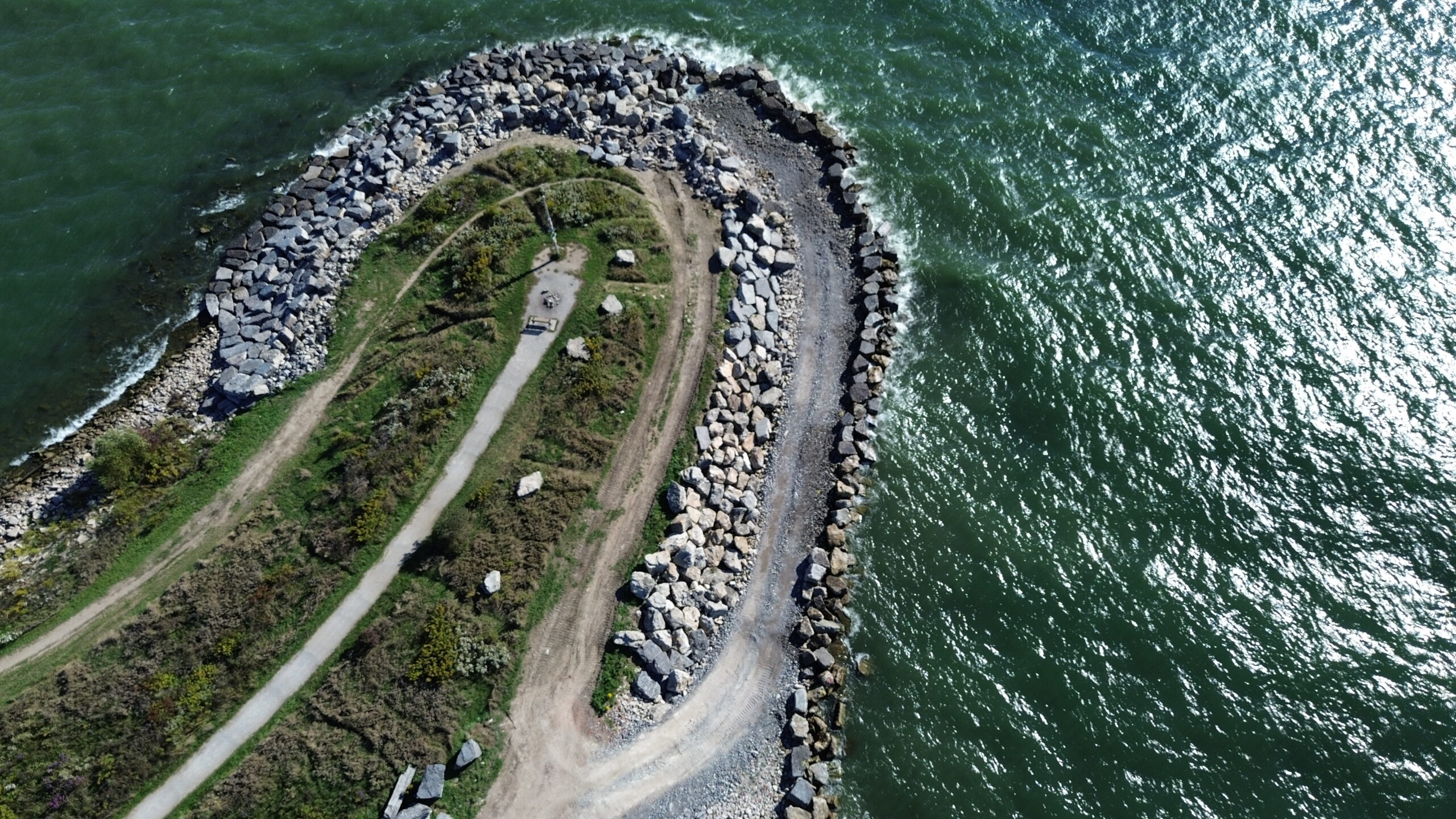
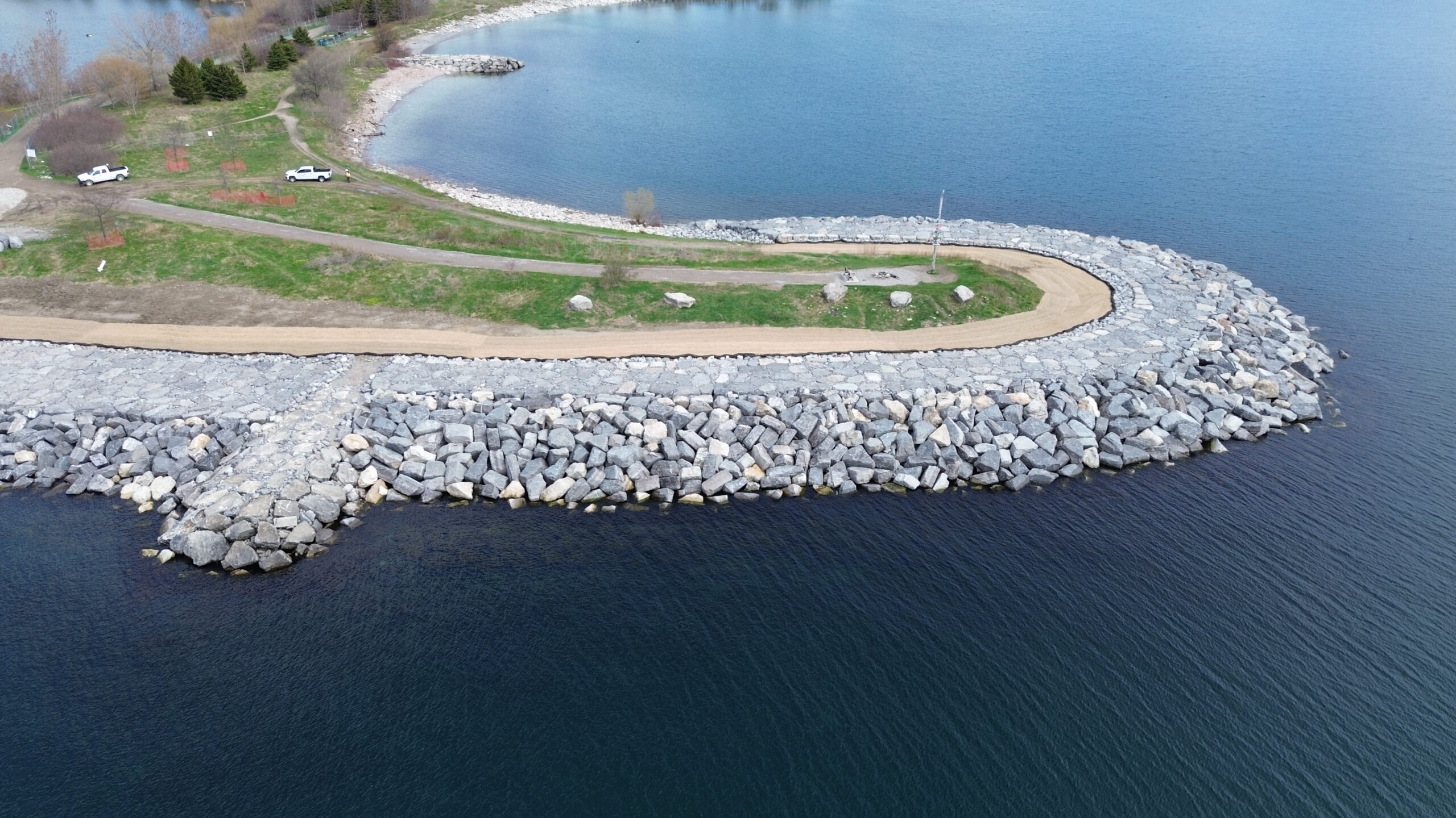
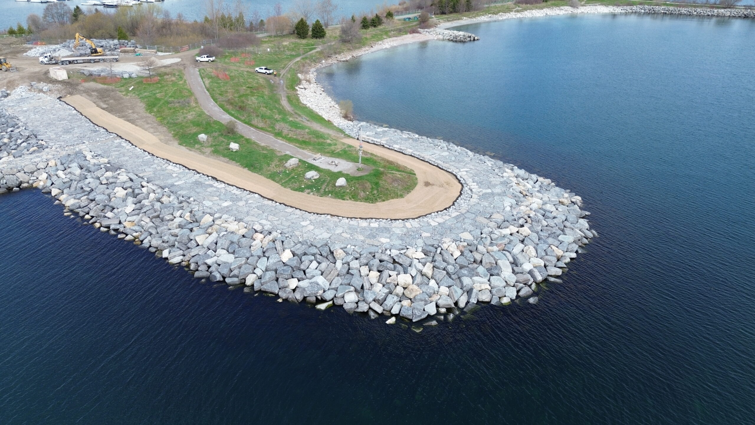
A particularly popular area of the park is Whimbrel Point, which is part of the Phase 1 project work. For three to five days a year, Whimbrels use this area as a resting point on their migration to their breeding grounds in the Arctic.
The rocky headland is favoured by the Whimbrels, and the park hosts a “Whimbrel Watch” every year to celebrate their return to Whimbrel Point.
Work on Whimbrel Point was completed in Spring 2026. Restoration work is underway and is anticipated to be complete before the 2026 Spring Bird Festival. Construction crews aim to be opening Whimbrel Point to the public during spring migration and on evenings and weekends following restoration work.
Part of project access (see above) will also include driving along a trail that crosses through the wetland area.
To protect species within the wetland, fencing on either side of the trail will also include turtle fencing, which will prevent turtles and other animals from entering the access route.
Additionally, TRCA will conduct visual inspections of the access route in the wetland area to ensure no species are harmed during work.
TRCA will work diligently to ensure species in the project location are considered for the duration of the project. Areas affected by construction will undergo restoration plantings, and any areas where construction activities could impact sensitive habitat or wildlife will be considered.
Progress Updates
Summer 2025:
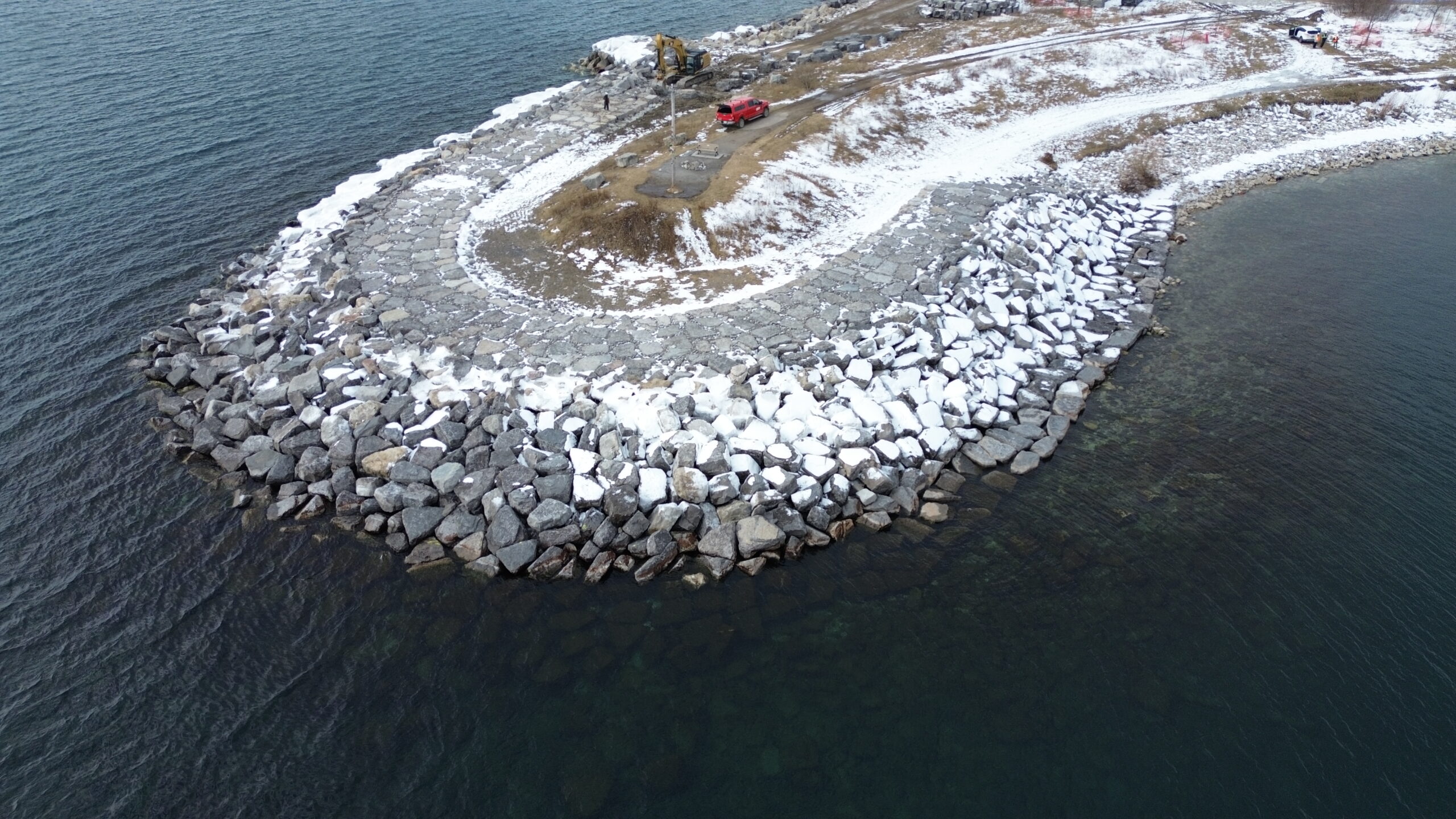
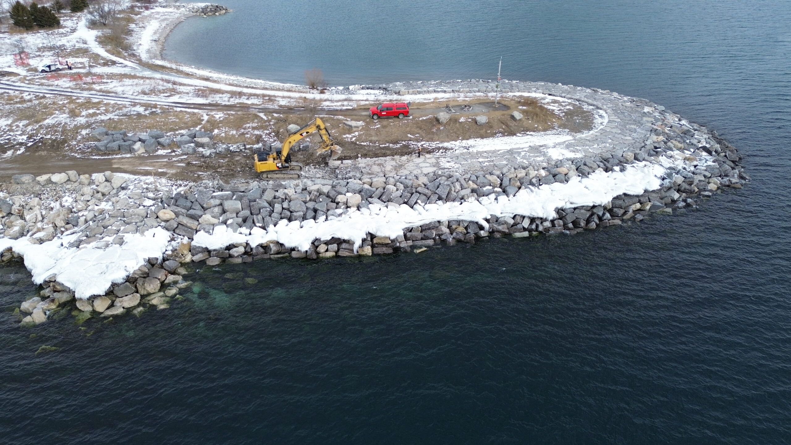
Construction teams have been hard at work over Spring 2025 stockpiling stone and have begun work to protect the Whimbrel Point headland from continued erosion damage.
The access road to install the perimeter of the shoreline protection work is complete, and crews are working on installing stones as large as 6 tonnes to protect the shoreline!
This work will prevent future erosion damage and improve and expand Whimbrel habitat.
The preexisting stones used by Whimbrels on the headland will be reused to maintain consistent habitat, and work on the headland is expected to be finished before the spring 2026 bird migration.
PHOTO GALLERY
Fall 2025:
Work on the Whimbrel Point headland has continued and is making great progress. See the update photos below for more details.
Winter 2025:
Work on the Whimbrel Point headland is nearing completion, and is expected to be complete in Spring 2026. See the update photos below for details.
Spring 2026:
Work on Whimbrel Point is complete and restoration work is underway. Part or all of Whimbrel Point may be open to the public on evenings and weekends following completed restoration work, pending construction access. Work continues along the southern shoreline to repair badly damaged areas and provide long term erosion protection.
Frequently Asked Questions
Why are sections of park trails being used for construction access?
Alternate access routes were considered and consultation with local stakeholders, and the Councillor’s office identified the following concerns with alternate on-street routes:
-
- Student Safety & Congestion: Many students walk, bike, and take transit to access the elementary school, secondary school, and Humber College Campus along Colonel Samuel Smith Park Drive and cross at various points along the road. The street is also highly congested during peak school pick-up and drop-off times. Directing construction vehicles away from this street eliminates potential safety conflicts and delays in an already busy school zone. The recommended access route also prevents delays and conflicts for residents and general road users on Thirteenth Street.
-
- Parking: The recommended construction access route eliminates the need for parking restrictions at the south end of Thirteenth Street and does not impact access to the parking lot at the south end Colonel Samuel Smith Park Drive.
How many trucks will be using the access route?
Up to eight trucks per day are expected between 7:00 a.m. and 4:00 p.m., Monday to Friday (excluding holidays).
Which trails are closed and when?
The trail detour map shows trail closures during construction. Some trails shown in yellow will be open weekdays after 4:00 p.m. and on weekends and holidays to allow park access and trail connections during the construction. See the Access Map for more information.
What is TRCA doing to protect wildlife?
Wildlife protection is a priority and TRCA is taking the following measures to limit construction impacts by:
- Regularly inspecting the construction access route to prevent vehicles from hitting wildlife
- Monitoring the site for nesting and other wildlife activities
- Avoiding tree and vegetation removals during nesting periods
- Minimizing tree and vegetation removals to only what is necessary to facilitate the construction
- Installing turtle trench fencing along the wetland area to prevent turtles from crossing or nesting in the construction access route.
- Avoiding areas of the site used by migratory birds during migration windows (to ensure Whimbrel Point is available to migratory Whimbrels)
What are the impacts to trees in the park?
TRCA arborists have worked closely with Urban Forestry at the City of Toronto to develop a tree protection plan to prevent impacts to trees.
This work has included a survey of all trees on site, the species, health, potential impacts, and protection strategies.
Three trees and six stems (less than 10cm diameter) at the south end of the park cannot be protected, and a current anticipated 13 root injuries may occur as a result of installing the turtle protection fencing near the wetland.
TRCA has obtained permit with Urban Forestry for these impacts and working with them on mitigation measures to decrease the injuries to trees wherever possible.
New trees will be planted to provide compensation for the removed and injured trees.
All other trees near construction activity will have Tree Protection Zone fencing installed around them to keep construction activity an appropriate distance away and prevent root damage.
Why will the work take three years?
The shoreline area being repaired is long (500m), and the type of shoreline protection needed due to deep water and heavy wave action uses very large stones.
These stones are placed carefully one by one along the shoreline, and are placed according to detailed plans for the best shoreline protection. This type of construction for such a long segment of shoreline requires multiple years to complete.
How will work impact bird migration?
There will be no active construction on Whimbrel Point during the two-week Whimbrel migration period. Construction will be planned to limit impacts and allow increased park and trail access during this period, and there will be no tree removals during bird migration windows to limit impact to birds.
How is this work being funded?
This project is funded by the City of Toronto and also received federal grant funding from Infrastructure Canada’s Disaster Mitigation Adaptation fund.
The total cost for both Phase I and Phase II of the Colonel Samuel Smith Park project is projected at $12 million, which will protect the park and habitat from erosion and flooding long-term.
Why were the current designs chosen?
The southern shoreline of Colonel Samuel Smith was assessed and is classified as an “open coast” environment subject to harsh wind and wave action. This environment is too harsh for trees and shrubs alone to provide effective erosion protection, so the use of large stones is needed to prevent shoreline damage.
Native tree and shrub plantings will be included in protected areas near the shoreline where plants can thrive and further reduce erosion and run-off.
Contact Us
For more information regarding this project, please contact:
Robyn Cox, Senior Project Manager
Erosion Risk Management
Restoration & Infrastructure Division
robyn.cox@trca.ca
416-505-3241