TRCA’s Restoration Plan for the Brock Lands
is available for download.
Project Background
On January 18, 2011, Toronto and Region Conservation Authority (TRCA) acquired the former Brock North and South Landfill sites, collectively known as the Brock Lands, from the City of Toronto.
These lands are located north and south of the 5th Concession Road, in Town of Ajax and City of Pickering.
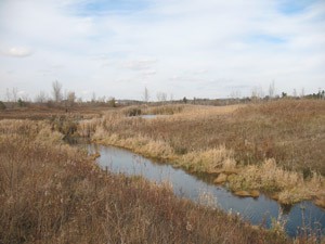
The property is 392 ha and located adjacent to two major natural corridors that offer critical wildlife habitat and connectivity to other important habitats within the Duffins Creek watershed.
From a regional hydrogeological perspective, these lands play a unique role as both recharge and discharge areas of regional groundwater.
Select the image below to view the full-sized map.

Vision
The Brock Lands will be restored to support functioning, diverse and self-sustaining communities of native plants, fish and wildlife.
Through careful planning, ongoing monitoring, and site management, these lands will become a public destination, offering a variety of recreational and cultural experiences that are appropriately integrated on the landscape to ensure natural and human heritage resources are protected.
These lands will also facilitate important regional trail linkages and provide connectivity to the planned Seaton Natural Heritage System, west of the property and the Greenwood Conservation Area to the east, resulting in 3,313 ha of connected natural green space.
Restoration Plan
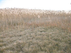
The terrestrial landscape and hydrologic functions of the Brock Lands have been significantly altered through previous aggregate extraction and landfill operations.
TRCA estimates that 143 hectares or 36% of the lands have been disturbed through previous land use activities that have altered the topography, drainage, and ability to support historic vegetation.
Through a planning process involving TRCA and key staff representatives from the Town of Ajax and the City of Pickering, TRCA has prepared a Restoration Plan to achieve a self-sustaining natural system that contributes to the overall health of the Duffins Creek watershed.
The Restoration Plan provides a framework to protect and restore the natural ecosystems by ensuring the health and diversity of native species, habitats, landscapes, and ecological processes.
The goal of the Restoration Plan is to protect and restore ecological function and resilience to both aquatic and terrestrial systems.
To achieve this goal the Restoration Plan focuses on the following objectives:
- Restore and enhance altered hydrology and sensitive groundwater zones;
- Enhance landform and soil conditions to promote self-sustaining natural communities;
- Restore natural cover and provide connectivity at both the local and regional scale; and
- Create and enhance optimal fish and wildlife habitat.
Challenges to Restoration:
Invasive Species
Altered Hydrology
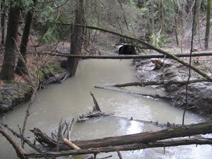
Stream bank Erosion
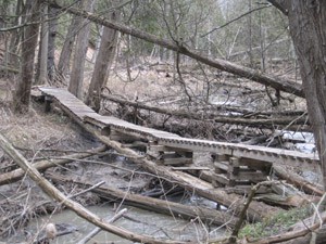
Barriers to fish migration
Restoration Opportunities:
Restoration opportunities fall into three broad categories: terrestrial, drainage and aquatic.
These restoration opportunities address the need for improving natural cover such as forest habitats, recreating natural surface flows and infiltration over the landscape to support wetland and stream function and protect groundwater, and improving instream habitat.
Implementation of the Restoration Plan is expected to achieve the following deliverables:
- 139 ha of improved terrestrial habitat
- 26 ha of created or enhanced wetland habitat
- 14 sub-catchments restored to capture flow of water generated by 1,035 ha of land
- 142 ha of improved stream edge habitat
- 14.7 km of improved headwater streams that support coldwater fisheries
- 143 ha of improved landform and soil conditions that protect groundwater, support natural site drainage and promote self-sustaining natural cover
- Installation of essential structures such as nest boxes and log tangles to promote creation of wildlife habitat
Implementation of the Restoration Plan
TRCA has identified five priority restoration areas. Detailed site prescriptions to restore the ecological function of these impaired sites will be implemented over the next five years.
The first priority area includes 10 ha of land located south of the 5th Concession in the Town of Ajax. Previous aggregate extraction activities have altered the natural landscape and drainage in this area.
Restoration of the site involves the placement of clean fill, which will be shaped to collect and direct surface flow into a newly created hardwood swamp. The hardwood swamp will treat and cool surface water and will discharge into a small tributary that flows into East Duffins Creek.
Restoration of this area will improve habitat for fish and wildlife communities, including Atlantic Salmon and brook trout, and will provide future recreational opportunities for the public.
Master Plan
The Restoration Plan will help guide the preparation of a master plan to ensure that integration of planned recreational facilities and public use areas are in harmony with the ecosystems of the property.
The master plan will explore the potential of this property to provide numerous recreational opportunities, trail connections and interpretation of natural and cultural heritage features.
![]()
![]()
![]()
For more information, please contact:
Clifton Coppolino, Restoration & Resource Management
clifton.coppolino@trca.ca
(365) 566-2359