Toronto and Region Conservation Authority (TRCA) is developing a management plan for TRCA-owned properties located within the Niagara Escarpment Parks and Open Space System (NEPOSS).
The NEPOSS Properties Management Plan will establish direction for the long-term protection, use, and management of these lands.
Explore the Project


Project Background
In 2022, Toronto and Region Conservation Authority initiated the preparation of a Management Plan for four TRCA properties located within the Niagara Escarpment Parks and Open Space System (NEPOSS).
The Management Plan will provide direction on how to protect, conserve, and restore the valuable ecological features and functions of these conservation lands, while also guiding their current and future uses.

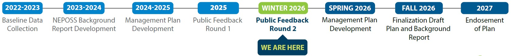
The management planning process is being conducted in several phases consisting of the following key activities:
- Compiling background materials and research
- Forming a vision statement and outlining goals and objectives
- Holding public and technical advisory committee meetings
- Holding public information and consultation sessions
- Developing management recommendations for trails, and other public uses
The Management Plan itself will include a description and evaluation of the property based on relevant plans and policies, existing resource inventories and environmental conditions, site limitations, and opportunities.

Additionally, the Plan will delineate management zones for the site to guide the types and levels of appropriate activities.
The Plan will make recommendations for future initiatives, including the protection of natural features and habitat regeneration based on an ecosystem approach to planning and management.
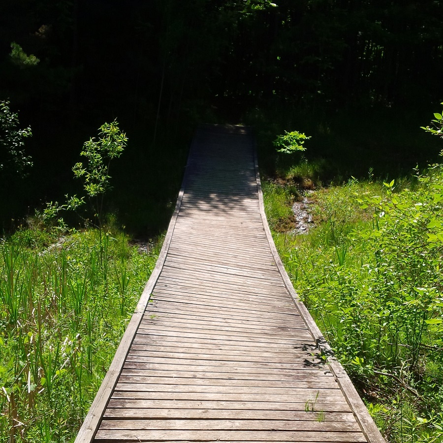
Finally, plans for the trails and other public uses will be presented.
Study Area
Select the image below to view the full-sized map.

The study area comprises four properties: Glen Haffy Conservation Park and the Glen Haffy Extension within the Town of Caledon, and the Humber Valley Tract and the Mono Mills Lowlands within the Town of Mono.
The TRCA NEPOSS Properties, situated in the headwaters of the Humber River, cover 516 ha (1,275 acres) and are home to a wide range of environments including plantation forests, intact mixed forests, open meadows, and wetland communities.
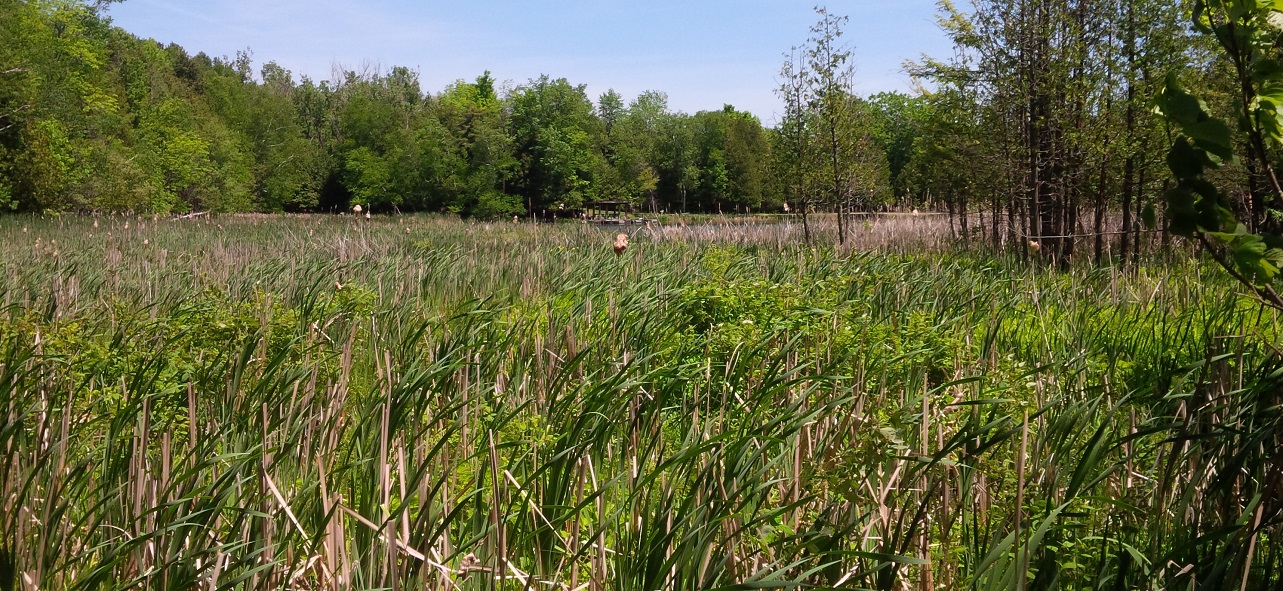
The Properties are also uniquely located at the convergence of the Niagara Escarpment, a designated UNESCO World Biosphere Reserve, and the Oak Ridges Moraine, and provide a vital and dynamic part of the connected greenspace system.
Furthermore, they are located within the jurisdiction planning area of the Niagara Escarpment Plan (2021), the large-scale provincial land use plan regulating the protection and development of lands within the Niagara Escarpment.
Engagement
The management planning process provides that all views respecting the proposed environmental management and social activities of the Properties be taken into consideration during the development of the Management Plan.
The Public Advisory Committee (PAC) will provide a forum for public input and feedback and will assist TRCA with building and maintaining relationships with other interest groups in the surrounding communities.
The PAC will also advise TRCA on the Plan’s draft vision statement, the draft goals and associated objectives of the Plan, and the development and prioritization of the Plan’s recommendations.
The Government Agency Advisory Committee (GAAC) will provide input into the management planning process. It will assist TRCA with ensuring that the Management Plan is in conformance with existing government policies and plans.


Based on guidance from Aboriginal Affairs and Northern Development Canada (AANDC) and the Ministry of Aboriginal Affairs (MAA), TRCA created an Aboriginal Community contact list that listed First Nations that had established or asserted rights and interests in the Study Area.
The First Nations that were identified are listed below:
- Alderville First Nation
- Beausoleil First Nation
- Chippewas of Rama First Nation
- Curve Lake First Nation
- Chippewas of Georgina Island First Nation
- Hiawatha First Nation
- Huron-Wendat Nation
- Mississaugas of Scugog Island First Nation
- Mississaugas of the Credit First Nation
- Six Nations of the Grand River
Indigenous engagement was initiated on November 28, 2024, which included a letter to the First Nations outlining the project and their potential involvement, and a study area map.
Public use and stewardship of the NEPOSS Properties is important to the community. As such, it is important that the public provides meaningful input in the planning process.

To facilitate a wide range of opportunities for input, several techniques will be used to generate a high level of awareness and public comment including surveys and Public Information Centres (PICs). For more information, please contact us.
Public Information Centre #1
The first Public Information Centre (PIC) was held on June 25, 2025, at the Caledon East Community Complex (6215 Old Church Road, Caledon).
Background information on the project was provided, and the public was asked to provide feedback on the draft vision statement, goals, objectives, and management zones that have been developed for the management plan.
Six panels were featured at the PIC. The panels included maps and provided information on the following:
- A description of the Niagara Escarpment Parks and Open Space System (NEPOSS).
- The location of the four properties that TRCA owns within the NEPOSS and their environmental significance.
- Who is involved in the development of TRCA’s NEPOSS Management Plan.
- The Plan’s draft vision statement, goals, and objectives.
- The draft management zones developed for each property.
A comment form was provided at the PIC. Comments and feedback were requested to be submitted via email during the two weeks following the meeting.
A brief survey was also made available during that time.
PIC #1 Materials:
- PIC #1 Panels
- PIC #1 Comment Form
- PIC #1 Survey
- Meeting Notice: NOTICE For PIC 1 – TRCA NEPOSS Properties Management Plan (Glen Haffy Management Plan)
Public Information Centre #2
The second Public Information Centre (PIC) was held on February 24, 2026, at the Caledon East Community Complex (6215 Old Church Road, Caledon).
Background information on the project was provided, and the public was asked to provide feedback on the development concepts that have been developed for the management plan.
In addition to the six panels that were featured at PIC #1, one new panel was displayed. The panels included maps and provided information on the following:
- A description of the Niagara Escarpment Parks and Open Space System (NEPOSS).
- The location of the four properties that TRCA owns within the NEPOSS and their environmental significance.
- Who is involved in the development of TRCA’s NEPOSS Management Plan.
- The Plan’s draft vision statement, goals, and objectives.
- The draft management zones developed for each property.
- The development concepts for Glen Haffy Conservation Park and Glen Haffy Extension.
A comment form was provided at the PIC. Comments and feedback were requested to be submitted via email during the two weeks following the meeting.
Have feedback? Please provide your comments to nadine.abrams@trca.ca by Wednesday, March 25, 2026. Please add “Glen Haffy Management Plan” to your email’s subject line.
PIC #2 Materials:
- PIC #2 Panels
- PIC #2 Comment Form
- Meeting Notice: Meeting Notice: NOTICE For PIC 2 – TRCA NEPOSS Properties Management Plan (Glen Haffy Management Plan)
Online Survey
A digital survey was developed to provide an opportunity for the public to provide feedback on recreational activities and infrastructure improvements of the Glen Haffy Conservation Park and Glen Haffy Extension.
The survey aimed to create a better understanding of:
- How often a visitor frequents the properties
- The types of recreational activities that are most enjoyed in the Glen Haffy Conservation Park and Glen Haffy Extension
- The types of recreational activities visitors would like to see offered at the Glen Haffy Conservation Park and Glen Haffy Extension (e.g., disc golf)
- The types of improvements that visitors would like to see happen in the Glen Haffy Conservation Park and Glen Haffy Extension
The online survey was made available on April 14, 2025 and was closed on December 31, 2025.
Status Report
In 2022, TRCA initiated the preparation of the Management Plan for the NEPOSS Properties.
The Management Plan is being developed following the Ministry of Natural Resources NEPOSS Planning Manual as well as a TRCA management planning model that has been successfully implemented in the past for properties such as the Oak Ridges Corridor Conservation Reserve and the Claireville Conservation Area.
The management planning process includes the development of a Background Report that identifies current land uses, policies, natural and cultural heritage resources, as well as public uses.

From that information, the Management Plan’s vision statement and goals and objectives will be created. The Management Plan will also contain management zones and associated recommendations, a trail plan, a public use plan and an implementation strategy outlining preliminary costs.
The planning process is as follows (click on the image to view full-sized):
Contact Us
For more information regarding this project, please contact TRCA Conservation Lands:
(416) 661-6600