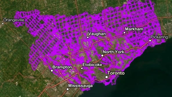
Toronto and Region Conservation Authority (TRCA) has completed its annual review and updates to the mapping that shows the TRCA Regulated Area across our jurisdiction.
The 2025 update of the TRCA Regulated Area map is now available on our Regulation Mapping webpage.
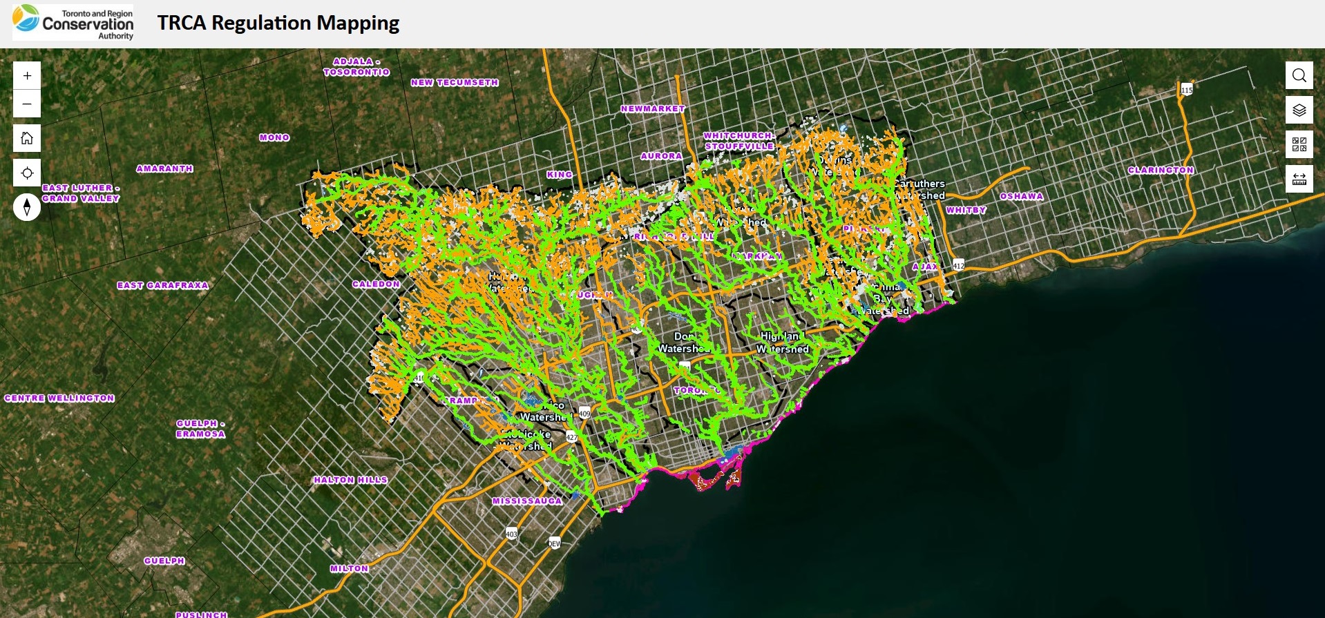
TRCA Regulation Mapping
In accordance with the Conservation Authorities Act and Ontario Regulation 41/24, the Regulated Area is made up of natural hazards and natural features that TRCA regulates, such as rivers, streams, flood plains, wetlands, valleylands, and Lake Ontario shoreline.
A TRCA permit may be required for work within a Regulated Area.
Each year, TRCA reviews the most current information available to inform the Regulated Area mapping update, which may include:
- Flood plain mapping updates
- Provincial wetland identification mapping
- TRCA Ecological Land Classification wetland identification mapping
- Digital elevation models
- Aerial photography
- Lake Ontario shoreline hazard assessment studies
- Site-specific information on certain regulated natural features or natural hazards, as revealed through TRCA permit application review and approval process
The 2025 Regulated Area mapping update is more fully described in an information report from TRCA staff prepared for the April 24, 2026 meeting of the TRCA Board of Directors. The staff report is available below under Important Links.
Tips for Viewing TRCA’s Regulated Area Map
- Access TRCA Regulation Mapping and agree to the Terms and Conditions.
- Navigate to the area of interest by searching by address or manually zooming in/out.
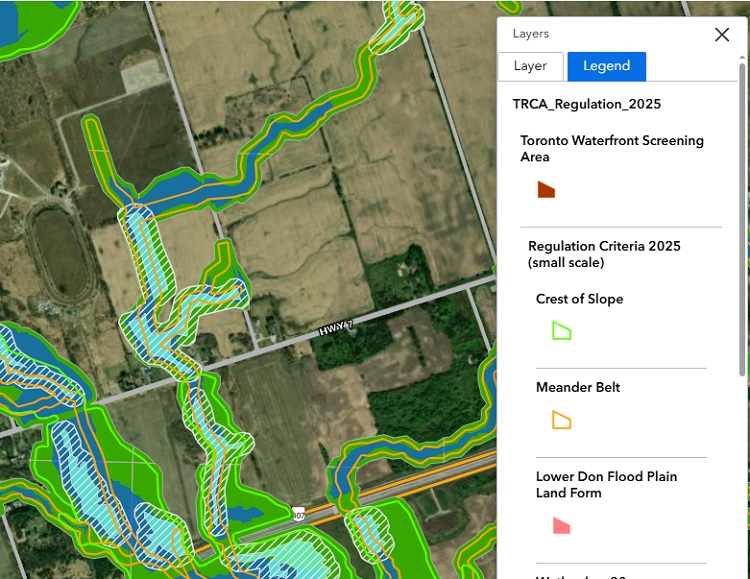
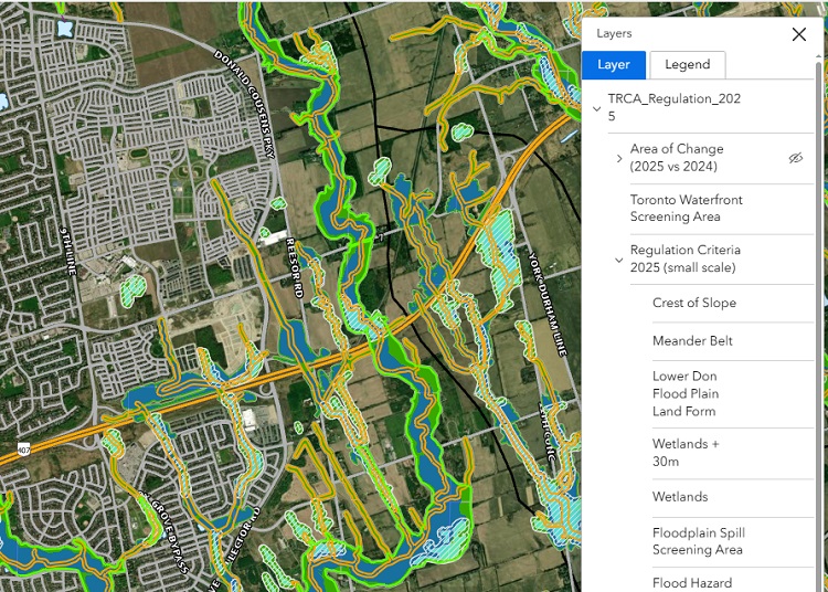
- To see the Legend: click the Layer icon and select the Legend tab.
- To see individual layers: click the Layer icon, select the Layer tab and expand TRCA Regulation 2025. Expand individual layers and turn on/off visibility (click on individual layer or eyeball icon).
- The following layers may be of interest:
- “Area of Change (2025 vs 2024)” compares the Regulated Area in 2024 with the updated Regulated Area in 2025.
- “Regulation Criteria 2025” shows features that make up the TRCA Regulated Area, such as wetlands and flood plains (the visibility of each of these features can be turned on and off).
If you have questions or comments on the regulation mapping, please contact regulationmapping@trca.ca.
How the Regulation Mapping Supports the
New Permit Regulation Effective April 1, 2024
On April 1, 2024, amendments to the Conservation Authorities Act governing TRCA’s permit regulation process were proclaimed (i.e., came into effect) by the Province of Ontario, including a new section: Part VI – Regulation of Areas Under Which Authorities Have Jurisdiction.
In addition, a new Minister’s regulation for all conservation authorities, Ontario Regulation 41/24: Prohibited Activities, Exemptions and Permits (O. Reg. 41/24) came into effect on April 1, 2024.
This new, single regulation replaced all individual conservation authority permit regulations, including TRCA’s previous individual regulation: Development, Interference with Wetlands and Alterations to Shorelines and Watercourses Ontario Regulation 166/06 (O. Reg. 166/06).
Under section 2(3) of the new regulation, O. Reg. 41/24, the distance conservation authorities regulate around all wetlands is 30 metres. Previously, under O. Reg. 166/06, TRCA regulated 120 metres around Provincially Significant Wetlands and all wetlands on the Oak Ridges Moraine.
For more information on the legislative changes that came into effect in 2024, please see the TRCA staff report on the Conservation Authorities Act Legislative and Regulatory Amendments Effective April 1, 2024.
The amendments to the Act and Regulation did not change conservation authorities’ ability to regulate natural hazards or natural features such as rivers, streams, flood plains, wetlands, valleylands, and Lake Ontario Shoreline.

A TRCA permit may be required for work within a Regulated Area.
TRCA has been reviewing and updating its mapping of Regulated Areas on an annual basis since 2019 as a best practice and as directed by TRCA Board of Directors. The new Ontario Regulation 41/24 includes specific mapping requirements for areas regulated by conservation authorities that generally align with TRCA’s best practice.
The following table lists the regulatory requirements for “Maps of Regulated Areas” on the left and how TRCA is meeting these requirements on the right.
| O. Reg. 41/24 Section 4 Requirements for Maps of Regulated Areas | TRCA Mapping Information |
|---|---|
| 1. An authority shall develop maps depicting the areas within the authority’s area of jurisdiction where development activities are prohibited under paragraph 2 of subsection 28 (1) of the Act which shall be filed at the head office of the authority and made available to the public on the authority’s website, and by any other means that the authority considers advisable. | TRCA’s Regulated Area maps are available to the public through the Regulated Area Search tool on TRCA’s website. This map is a visual tool that allows the public to view TRCA’s Regulated Area by searching using an address and placing a marker on the property of interest. The tool also enables the public to request more information from TRCA. The Regulated Area maps are also available on file at the TRCA head office. |
| 2. At least once annually, the authority shall, (a) review the maps referred to in subsection (1) and determine if updates to the maps are required; (b) make and file such updates to the maps at its head office if required; and (c) make the updated maps available to the public on its website and by any other means it considers advisable. |
Each year, TRCA reviews the Regulated Area maps to determine if updates are needed. A description of the annual update process and final updated mapping are made available to the public through the Regulated Area Search webpage and Regulation Mapping webpage on TRCA’s website. The Regulated Area maps are also available on file at the TRCA head office. |
| 3. Where new information or analysis becomes available that may result in significant updates to the areas where development activities are prohibited under paragraph 2 of subsection 28 (1) of the Act, including enlargements or reductions to such areas, the authority shall ensure that stakeholders, municipalities and the public are notified of the proposed changes in any manner that the authority considers advisable, including making any relevant information or studies available online at least 30 days prior to an authority meeting during which the proposed changes are on the agenda. | TRCA makes the updated mapping available to the public through TRCA’s Regulation Mapping webpage.
The online mapping tool includes an Area of Change layer and is posted at least 30 days before the TRCA Board of Directors meeting where the annual regulation mapping update is on the agenda. Following the Board meeting, the final Regulated Area maps are promptly uploaded to TRCA’s Regulated Area Search website and TRCA provides the information to our municipal partners to add to their municipal mapping platform as they find appropriate. This process is followed each year whether the mapping changes include significant enlargements or reductions of Regulated Areas. |
| 4. Where significant changes to the areas where development activities are prohibited have been made in accordance with subsection (3), the authority shall promptly update the maps described in subsection (1). | Outside of TRCA’s annual regulation mapping update, from time to time based on available funding, TRCA completes new flood plain mapping studies. Any changes to flood plain mapping that result from these studies are shared with partner municipalities and promptly uploaded to the Flood Plain Mapping Viewer on TRCA’s website. |
| 5. For greater certainty, in case of a conflict regarding the boundaries of the areas where development activities are prohibited under paragraph 2 of subsection 28 (1) of the Act, the description of those areas in that paragraph and in section 2 of this Regulation prevail over the depiction of the areas in the maps referred to in subsection (1) of this section. | Notwithstanding that the description of the Regulated Area prevails over the depiction of the areas on the map, TRCA endeavours to keep the Regulated Area maps as comprehensive and accurate as possible through our annual updates. |
Background on TRCA Maps of Regulated Areas

TRCA has a regulatory responsibility to protect people, the environment, and property from natural hazards associated with flooding, erosion and slope instability, and to conserve valleylands, wetlands, watercourses, and the shoreline of Lake Ontario.
The maps depict Regulated Areas within the TRCA area of jurisdiction and are governed by paragraph 2 of subsection 28(1) of the Conservation Authorities Act and section 4 of Ontario Regulation 41/24: Prohibited Activities, Exemptions and Permits.
The Regulated Area map is a compilation of various information sources informing the delineation of hazardous lands:
- Engineered flood plain mapping and estimated flood plain mapping are prepared by engineering consultants and assigned an allowance of 15 metres.
- Riverine erosion hazards are delineated by TRCA and assigned an allowance of 15 metres.
- Lake Ontario shoreline hazards are prepared by engineering consultants and assigned an allowance of 15 metres.
- Wetlands are based on Ministry of Natural Resources and TRCA data sources. All wetlands greater than 0.5 hectares in size are mapped plus a distance of 30 metres.
- Watercourses are mapped by TRCA using orthophotography.
Under the Conservation Authorities Act and Ontario Regulation 41/24, property owners must apply for a permit from TRCA if they are planning to undertake certain activities on a property that falls within our Regulated Area.
The Act and Regulation aim to:
- Prevent or reduce risk to life and property from natural hazards associated with flooding, erosion, and slope instability
- Minimize negative impacts on natural features, functions, and systems
- Prevent the creation of new hazards or aggravation of existing hazards
More accurate mapping gives property owners a better idea of whether a permit from TRCA is required before undertaking work on a property to reduce risk to people, property, and the environment.
If you have questions or comments on the regulation mapping, please contact regulationmapping@trca.ca.
Important Links
- April 24, 2026 – Staff report to the TRCA Board on the Conservation Authorities Act Regulated Area Mapping Annual Update
- April 25, 2025 – Staff report to the TRCA Board on the Conservation Authorities Act Regulated Area Mapping Annual Update
- March 22, 2024 – Staff report to the TRCA Board on the Conservation Authorities Act Regulated Area Mapping Annual Update
- March 22, 2024 – Staff report to the TRCA Board on the Conservation Authorities Act Legislative and Regulatory Amendments Effective April 1, 2024