The goal of the Archaeological Heritage Resource Management Program is to manage the archaeological resources found on TRCA lands with respect to legislative requirements and approved technical practices.
Archaeological sites on Toronto and Region Conservation Authority (TRCA) lands span 11,000 years of human habitation of southern Ontario. To date, approximately 1,200 acres of TRCA property have been examined for archaeological sites and more than 100 sites have been located. Archaeological surveys are triggered by internal partners and projects, such as habitat enhancement projects carried out by TRCA’s Restoration Services Habitat Protection and Restoration, as well as external partners such as municipalities or utilities companies as a component of the Environmental Assessment process.
The goal of the Archaeological Heritage Resource Management Program is to manage the archaeological resources found on TRCA lands with respect to legislative requirements and approved technical practices, with guidance and input from culturally descendant communities whenever possible. Archaeological resources on TRCA lands will be managed as a community resource. Ongoing programs will identify new resources and make appropriate recommendations regarding the management of the resource.
Recent Examples of Field and Research Projects
The Lost Brant Site, Humber River watershed, Richmond Hill
The Lost Brant site, situated by Wilcox Lake, has been subject to over 20 years of archaeological investigation and new findings each year never fail to impress. Archaeologists have located over 60 sites around the lake area. These sites represent several periods of occupation and were inhabited by peoples from PaleoIndian, Archaic, and Woodland periods. This area was an inviting location for prehistoric peoples. As the evidence suggests, Lake Wilcox has been a well utilized location spanning over 10,000 years of history.
The TRCA has been excavating at the Lost Brant site since 1992, but fairly intensively from 1999-2002. During this excavation, over 9,400 artifacts and 19 features were identified and recovered. These artifacts indicate several activities would have been conducted on this site. Those activities would have included game processing, storage, refuse, and cooking/heating. The nearby lake made for an ideal place for repeated occupation over thousands of years, serving as “nature’s grocery store”.
Excavations at Lost Brant Site have resumed. Several projectile points and some ceramic rim fragments have been recovered thus far. This site is an important multi-component site in that it demonstrates the length and diversity of occupation. The current cluster the TRCA is working on appears to be primarily Late Archaic and Early Woodland dating to roughly 3000 years ago.
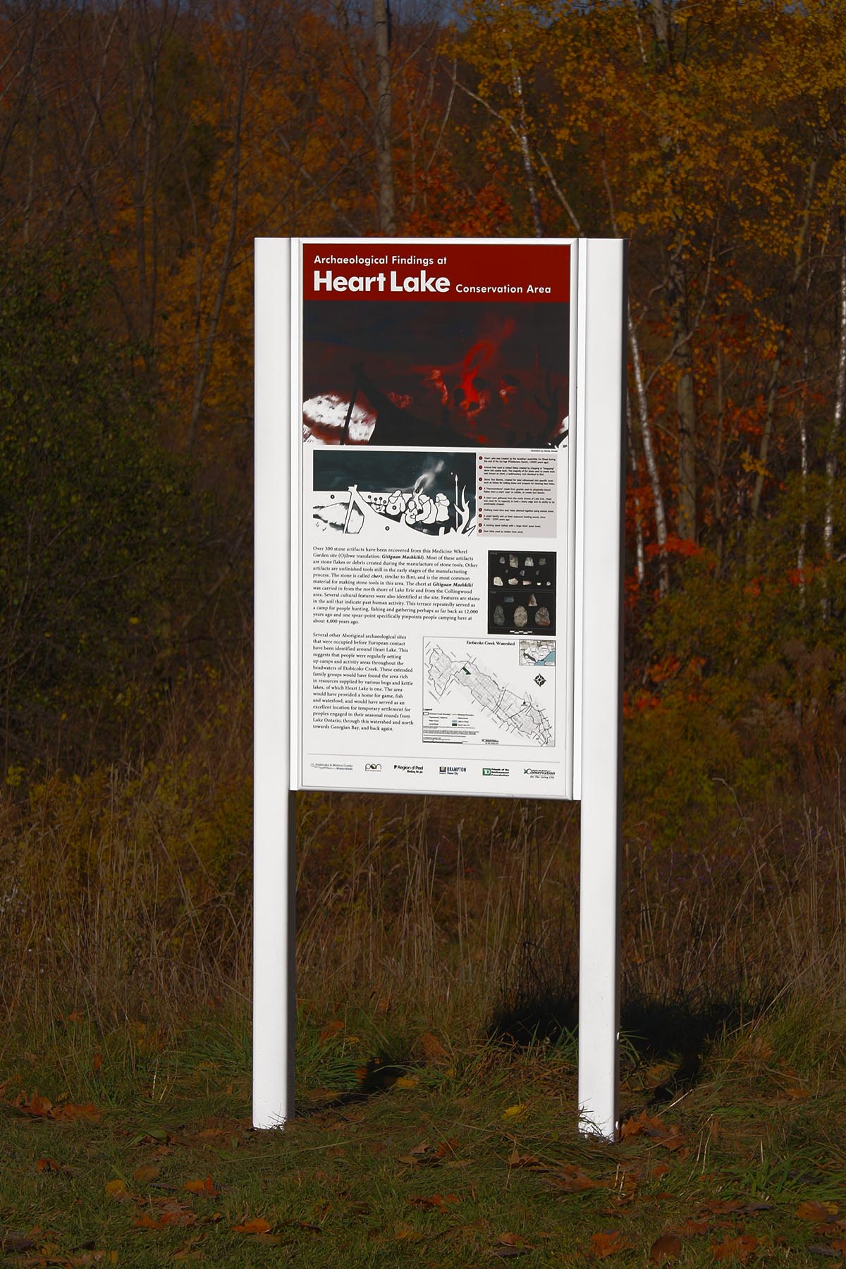
Heart Lake Conservation Area, Etobicoke Creek watershed, Brampton
Several archaeological sites have been identified within the conservation area around Heart Lake that were occupied before European contact. This suggests that First Nations groups were regularly setting up camps and activity areas throughout the headwaters of Etobicoke Creek. These people would have found the area rich in resources supplied by the various kettle lakes and bogs, as well as Heart Lake itself. The area would have provided a home for game, fish and waterfowl, and would have served as an excellent location for temporary settlement for nomadic peoples engaged in their seasonal rounds.
More than 200 stone artifacts have been recovered from the Gitigaan Mashkiki site. Gitigaan Mashkiki is the Ojibway phrase for Medicine Garden. Most of these artifacts are stone flakes or debris created during the manufacturing of stone tools. Other artifacts found are unfinished tools still in the early stages of the manufacturing process. The stone is called chert, a type of flint, and it is the most common material for making stone tools in this area. The chert at the Gitigaan Mashkiki site comes from the north shore of Lake Erie and the Collingwood area. Several features were also identified at the site. Features are stains in the soil that indicate past human activity. These findings suggest that the site likely served repeatedly over the millennia as a camp for people hunting, fishing and gathering and may date to as far back as 12,000 years ago.
For information about the Heart Lake medicine garden click here.

Lewis Site, Rouge River watershed, Whitchurch-Stouffville
Due to the proposed widening of Stouffville Road that would impact a nineteenth century archaeological site, excavation was initiated in 2006 and continued until 2009. Part of this excavation was conducted as a component of the Boyd Archaeological Field School. The excavation at the Lewis Site (AlGu-365) resulted in the documentation of a substantial nineteenth century settlement that included over 60,000 artifacts and a number of foundations including a kiln complex, a homestead, several structures of unknown or speculative function and two stone lined wells. The artifacts include tableware and personal grooming and ornamental objects, several coins, ceramic doll fragments and clay pipe fragments. Further to this, a number of structural items were recovered including nails and pane glass.
Royal Rouge Trail, Rouge River watershed, Toronto
Have you ever wondered what’s buried in your back yard? In the summer of 2010, several Scarborough families were surprised to learn that theirs held the remains of 5,000-year-old Aboriginal campsites, undisturbed beneath the layers of soil and sod. A total of three small aboriginal sites were discovered and excavated. To read more about the Royal Rouge Trail Project and the excavation that took place in 2010, please read the full story here.
Graham House Site, Duffins Creek watershed, Pickering
The Graham House site was encountered during a survey of authority lands at the Claremont Field Centre in the Duffins Creek watershed in 2007. During the following field season it was used as a teaching site for the TRCA’s ‘Boyd Archaeological Field School’ where high school students under the supervision of TRCA archaeologists uncovered sections of the probable homestead occupied by the blacksmith George Graham and his family. Census information dates their original settlement to the 1860’s.
In 2009 and 2010 the ‘Boyd Field School’ returned to continue excavations at the Graham site. Connected to the fieldstone foundations was a collapsed stone-lined well or cistern, implying that the family had a water source within an attached outbuilding at the rear of the house. In addition, thousands of artifacts were recovered relating to the occupation of the house including domestic ceramics and glass, children’s toys, and hundreds of horseshoe nails indicating Ferrier activities on the property.
Frenchman’s Bay, Lake Ontario waterfront, Pickering
As part of the Harbour Entrance EA project at Frenchman’s Bay , TRCA’s Archaeological Resource Management Services (ARMS) unit was asked to conduct an archaeological Stage 1 (archival research and archaeological potential modeling) investigation of the area being studied by the Environmental Assessment to determine the potential for archaeological material.
ARMS utilized extensive archival materials and conducted site visits paying close attention to the local topography, identifying landscape features that may be indicators of archaeological sites or other cultural heritage landscapes. Information was exchanged with local community members whose ancestors may have owned and lived on property in the area.
The Frenchman’s Bay EA project gave the ARMS unit a chance to connect with the local community and to provide them with new insight about their local history and vise versa.
Sebastien Site
Situated on Provincial lands in Seaton (north Pickering), the Sebastien site (AlGs-341) was discovered by archaeologists in an agricultural field during the Oak Ridges Moraine/Seaton Class EA process which took place in 2004-05. The results of the Stage 2 (pedestrian survey and test pitting) and Stage 3 (delineation of site extent) investigations yielded a sample of 2,246 artifacts and determined that the site is about 2.5 hectares (6 acres) in size. Although dating cannot be certain for all recovered artifacts, some have been firmly dated to the Middle Iroquoian period (A.D. 1275-1325). These artifacts are representative of the ancestral Huron-Wendat people.
TRCA Archaeology has entered into an agreement with the Province of Ontario to help understand the cultural resources of the Sebastien site, allowing us to conduct detailed archaeological excavations by hand through public and educational programming. As a result, the Boyd Archaeological Field School excavated a small portion of the site for two weeks in August of 2012 with 20 high school students from across Ontario, to gather archaeological data and to facilitate their learning of southern Ontario Aboriginal history and archaeological methods. Programming is continuing at Sebastien during the 2012-13 school year in partnership with the Durham Catholic District School Board, for students from grades 4-12 to experience local archaeology and gain a better understanding of Durham Region’s past peoples.
- For summaries of past excavation and research projects click here
Protection by Avoidance
Finding and protecting new archaeological sites is the primary goal of the archaeological resource management program. When sites, or portions of sites, cannot be avoided they are excavated, which provides a wealth of information and understanding about past peoples’ lives and movements throughout our watersheds. However, in many circumstances new sites that are encountered can be avoided and left in place, perhaps for future generations to further explore.
Clairville Trail, Humber River watershed, Brampton
In 2010 the TRCA conducted an archaeological investigation along the length of a proposed pedestrian trail within Claireville Conservation Area. The trail was scheduled to extend along the Humber River, meandering through open meadows, forests, and old farm lanes over a distance of approximately 3.3 kilometres. During the assessment several archaeological sites were identified. This was not unexpected considering the rich cultural history that exists within Claireville Conservation Area.
Three sites were initially identified along the proposed trail alignment. Two sites had never before been encountered and were each represented primarily by lithic debitage, small flakes of toolstone left over from the creation of tools. These sites are now registered with the Province of Ontario through the Ministry of Tourism, Culture, and Sport. The third site encountered was originally identified in 2007 as an Aboriginal camp, a short term encampment where the rich resources within Claireville such as fish, waterfowl and game would have been exploited as part of a people’s seasonal round. The 2010 assessment determined that this site was larger than initially believed, and in fact extended into the proposed trail alignment.
Once these sites were identified, the TRCA committed to avoidance and protection measures, and as a result several new trail alignments were proposed. The new alignments had to be located at least 20 metres from the outer boundary of all of the identified sites. The TRCA returned twice to conduct additional archaeological investigations, and a fourth Aboriginal camp was encountered. Unfortunately, no diagnostic artifacts were recovered from any of the sites that could provide dates of occupation. However, all four sites are considered to have high levels of cultural heritage value and interest, and certainly tell a valuable story about the history of Claireville Conservation Area.
At the present time, the TRCA has recommended that all four sites remain in place with protection measures, and that additional trail alignments will have to be devised that will not impact the cultural landscape within Claireville Conservation Area. All future proposed trail alignments will necessitate further archaeological investigations.
Rouge Park Avoidance
Extensive habitat restoration works including tree planting and wetland enhancement and creation occur within Rouge Park on an annual basis. Together with the Rouge Park Alliance and the Friends of the Rouge Watershed, the TRCA has been instrumental in completing restoration works to improve the water quality, biodiversity and ecosystem health throughout the watershed. While this continues to be an on-going process the results of the earliest restoration projects are readily apparent and accessible to the public via trials in the vicinity of the Toronto Zoo.
The mandate of the Archaeology department at the TRCA is to ensure that Cultural Heritage, which includes the artifacts and other evidence left behind by past inhabitants of the area, receives the same level of protection and conservation as the natural environment when restoration works are planned. To this end, all projects completed within the park, from wetland creation to tree planting, are subjected to an archaeological assessment. Our preference is to preserve, rather than excavate, the archaeological sites encountered. As a result, trails and wetlands are redesigned to avoid archaeological sites, and tree planting crews are instructed to avoid the sites as well.
In any given field season, ten to twenty small Aboriginal sites and one or two 19th century Historic era sites are typically encountered within Rouge Park. Many of the Aboriginal sites are identified as small artifact scatters consisting of stone tool making debris and are representative of the many camps and hunting expeditions that travelled along the river banks and through the park over the past 10,000 years. The information gained through the archaeological assessment process can then be communicated to the public through park signage and literature. New trails designed for the Bob Hunter Memorial Park section of Rouge Park are an excellent example of this with a plan to incorporate landscape features from the 19th century village of Cedar Grove and provide information pertaining to the Aboriginal peoples who lived on these lands during the preceding millennia.