
Toronto and Region Conservation Authority (TRCA), in partnership with the City of Toronto, is developing long-term solutions to reduce flooding and shoreline erosion in Toronto Island Park.
The Toronto Island Park Flood and Erosion Mitigation Project is beginning the detailed design phase, building on the preferred solutions identified through the Class Environmental Assessment (EA).

Learn More About the Project




Project Objectives
The project’s main objectives are to:
- Reduce flood and shoreline erosion risks
- Protect people, homes, park infrastructure and important access routes
- Minimize the impacts of flood protection measures on park users and the natural environment, while incorporating opportunities to protect or enhance habitat
Study Areas
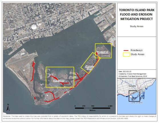
The project includes four study areas across Toronto Island Park: Ward’s Island, Algonquin Island, Centre Island, and Roadways.

Detailed Design
The detailed design phase will build on the preferred concepts identified through the Class EA. This work will involve further site investigations and technical assessments to develop detailed designs for each study area. Design development will be phased based on site priorities, with support from a consulting team led by GHD.
As work progresses, there will be opportunities for community members to share feedback and help inform the designs. More information will be shared as these opportunities are planned.
Preferred Concepts
The sections below provide a brief overview of the preferred concepts for each study area. Detailed design will further refine the size, layout and positioning of the proposed flood protection measures, while also considering landscaping and other public realm elements where appropriate.
Select a study area below to learn more. Additional information about the concepts and how they were selected is available in the Environmental Study Report.
Ward’s Island
The preferred concept for Ward’s Island includes a vegetated berm that follows the shoreline, with a section extending inland along First Street. The concept also includes adding sand to the existing beach north of the ferry dock and a groyne to help retain the added sand.
Select the image to view the preferred concept for Ward’s Island.
Algonquin Island
The preferred concept for Algonquin Island includes a berm that follows the shoreline along Seneca Avenue, curves around the Algonquin Island Association Clubhouse, and continues along Wyandot Avenue. The shoreline portions of the berm would be reinforced with a stone buttress for added support.
At the Queen City Yacht Club, proposed measures include raising portions of the land, constructing a concrete flood wall and a raised walkway, and incorporating existing flood protection measures installed by the club.
Select the image to view the preferred concept for Algonquin Island.
Centre Island
At Toronto Island Marina, the preferred concept includes raising portions of the marina storage yard and nearby roads. The concept also includes a berm along the shoreline just east of the marina and a steel sheet pile wall around Toronto Island BBQ and Beer Co.
Near the Centre Island ferry dock, the preferred concept includes a berm and an in-water stacked armourstone wall to the east, and a stepped concrete wall supported by steel sheet piles to the west.
Around Centreville, the preferred concept includes a naturalized shoreline with a berm along the top of the shoreline.
Select the image to view the preferred concept for Centre Island.
Timeline
Project History and Class Environmental Assessment (EA)
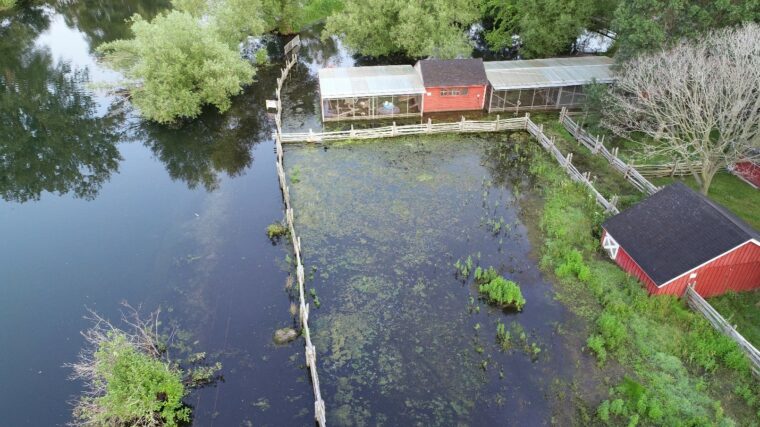
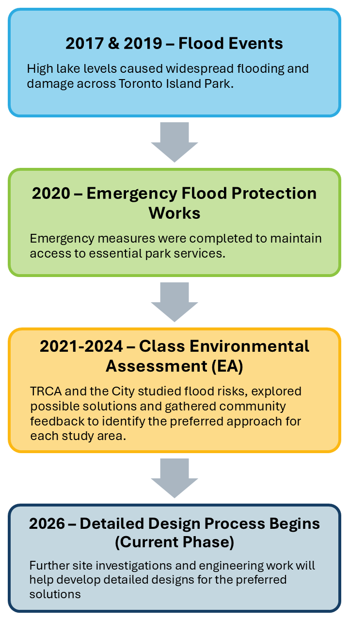
Significant flooding in 2017 and 2019 caused widespread damage across Toronto Island Park, affecting residents, businesses, park facilities, and access routes. These events highlighted the need for long-term solutions to reduce the impacts of future flooding and shoreline erosion.
Select a section below to learn more about the project’s history and the Class EA phase.
2017 and 2019 Flooding
In spring 2017, record-breaking water levels caused extensive flooding across Toronto Island Park.
The park was closed for almost three months, with flooding causing significant shoreline erosion, property damage, and debris accumulation. More than 800 residents, nearly 30 businesses, and two schools were affected.
In response, TRCA and the City of Toronto installed emergency mitigation measures across the Islands.
In spring 2019, Lake Ontario water levels exceeded the 2017 record by approximately 10 centimetres. Despite the higher water levels, flooding impacts were less severe, in part due to lessons learned from 2017 and temporary protection measures implemented in 2018.


2020 Emergency Works
In winter and spring 2020, TRCA completed emergency flood protection works:
- About 500 m of roadway was raised along Lakeshore Avenue and Cibola Avenue to maintain emergency vehicle access.
- A 125 m section of beach curb was installed on Ward’s Island to help protect the ferry terminal and improve public safety.
- Temporary flood protection measures were installed at the Island Water Treatment Plant.


Flood Risk Assessment
Following the 2017 high-water level event, TRCA and the City of Toronto undertook the Toronto Islands Flood Characterization and Risk Assessment Project.
This study helped identify flood risks and vulnerable areas across Toronto Island Park, informing the scope and study areas of the subsequent Class EA.
Class EA
A Class EA was undertaken between 2021 and 2024 in accordance with Conservation Ontario’s Class Environmental Assessment (EA) for Remedial Flood and Erosion Control Projects. Through this process, potential flood and erosion protection options were developed and evaluated, informed by technical studies, environmental considerations, and community feedback.
The Class EA identified preferred concepts for the four study areas, which now form the basis for detailed design. The assessment process and preferred concepts are documented in the Environmental Study Report (ESR).
Past Community Engagment
Community Liaison Committee
As part of the Class EA process, a Community Liaison Committee (CLC) was established to provide opportunities for representatives of local community groups to share feedback and help inform the development of the preferred concepts. Two meetings were held in February 2022 and February 2023.
Public Information Centres and Community Information Meetings
May 2023 – Community Information Meeting
A meeting was held with Toronto Island Park residents to discuss proposed flood protection measures near residential areas and their potential impacts. Residents had an opportunity to ask questions and provide feedback to help inform further development of the preferred concepts.
April 2023 – Public Information Centre #2
The second Public Information Centre (PIC) included a virtual open house and live webinar to share revised preferred concepts and provide opportunities for participants to ask questions about them.
March 2022 – Public Information Centre #1
The first PIC included a virtual open house and live webinar to present preliminary flood protection concepts and gather community feedback to inform their further development.
Class EA Documents and Notices
Class EA documents have been made available here for viewing following publication.
Class EA Notices
Notice of Completion (2024):
Notice of Intent:
Environmental Study Report (ESR)
- Environmental Study Report
- Appendix A – Supporting Studies and Reports
- Appendix B – Conceptual Design Evaluation Report
- Appendix C – Consultation Documentation
Past Public Engagement Materials
Public Information Centre #1 – March 8, 2022
Public Information Centre #2 – April 13, 2023
Project Updates
November 2026:
TRCA, in partnership with the City of Toronto, is beginning the detailed design phase of the Toronto Island Park Flood and Erosion Mitigation Project. Initial activities will focus on reviewing existing information and carrying out field investigations to better understand site conditions. These investigations will take place in various areas of Toronto Island Park over the coming months.
Contact Us
For more information regarding this project, please contact the Project Team at:
TorontoIslandsFloodProject@trca.ca