
The overall visionary concept of the West Bolton SNAP Action Plan is an interconnected network of trails and revitalized destinations.
The Trail and Places Master Plan provides the vision for this network, as well as guidance to inform the detailed design and implementation of the trail system and key trail nodes.

The proposed trails, cycling routes, and infrastructure and amenity improvements will be implemented over several years in alignment with existing Town of Caledon and Peel Region plans.
TRAIL AND PLACES MASTER PLAN


1. Walking Trails
The proposed West Bolton SNAP walking trails system consists of four distinct walks, each with its own set of characteristics and proposed interventions:
- Heritage Walk: an active, heritage- and culture-driven walk with public art, heritage and nature interpretive signage, and resting stations.
- Memory Lane Walk: a passive walk that places an emphasis on intergenerational interactions and nature interpretation.
- Humber River Valley Walk: a passive and meditative walk with opportunities for nature interpretation and art viewing.
- Harvest Moon Walk: an active and family-oriented walk incorporating activities for children as well as spaces to facilitate social interaction among residents.
Select image to view full-sized.

2. Cycling Trail
The proposed cycling trail is intended to provide cyclists with a fast and direct way to get to key destinations in the West Bolton neighbourhood and Bolton as a whole.
Select image to view full-sized.

3. Key Trail Node Designs
Jaffary’s Creek at Caven Presbyterian Church is a node along the Heritage Walk. The key experiences that this node offers include nature sights and sounds as well as a sense of local heritage.
The design objectives identified for this site during the West Bolton SNAP planning process include:
- Implementing erosion control measures alongside Jaffary’s Creek
- Working with Caven Presbyterian Church and local residents to create a new community space on the site
CONCEPT PLAN
Select image to view full-sized.

ARTIST RENDERINGS
Use arrow buttons to view before and after images. Select Read Now for full-screen view.
Concept design for illustrative purposes only. Detailed design will be completed as part of implementation.
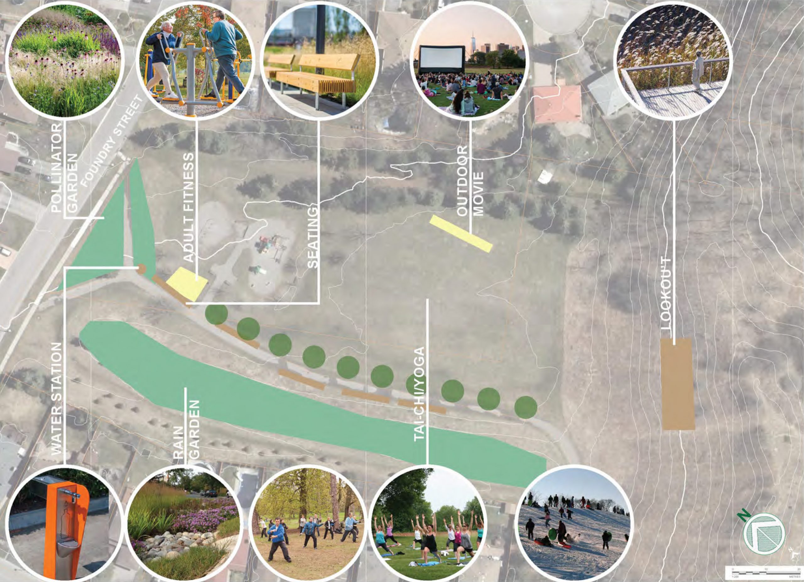
Foundry Park is an important node along the Humber River Valley Walk. This node offers experiences aligned with more passive recreational use, such as public art, health, nature, and community connections.
The design objectives identified for this site during the West Bolton SNAP planning process include:
- Integrating a diversity of functions and experiences across demographics, through increased seating, a flexible green space or lawn, a yoga pavilion, public art, native gardens, and creative programming
- Promoting recreational activities such as community gatherings, outdoor theatre, and yoga
- Planting more trees to increase the tree canopy and provide shade
CONCEPT PLAN
Select image to view full-sized.
ARTIST RENDERINGS
Use arrow buttons to view before and after images. Select Read Now for full-screen view.
Concept design for illustrative purposes only. Detailed design will be completed as part of implementation.
The hammerhead end of Ridgewood Crescent at the border with the Stationview Place is a trail node along the Memory Lane Walk.
The key experience that this node offers involves intergenerational activities, given the presence of a mix of families and seniors in the area, as well as elements of heritage appreciation of the historic Bolton train station (which was across the street from the site) and the history of Bolton as a fresh air destination for city dwellers.
The design objectives identified for this site during the West Bolton SNAP planning process include:
- Constructing an accessible pathway from the Stationview Place to Ridgewood Crescent to provide seniors with access to the Memory Lane Walk
- De-paving of a currently underutilized section of street to transform it into a public space
CONCEPT PLAN
Select image to view full-sized.

ARTIST RENDERINGS
Use arrow buttons to view before and after images. Select Read Now for full-screen view.
Ridgewood Crescent concept design by:
University of Toronto’s John H. Daniels Faculty of Architecture, Landscape and Design.
Concept design for illustrative purposes only. Detailed design will be completed as part of implementation.
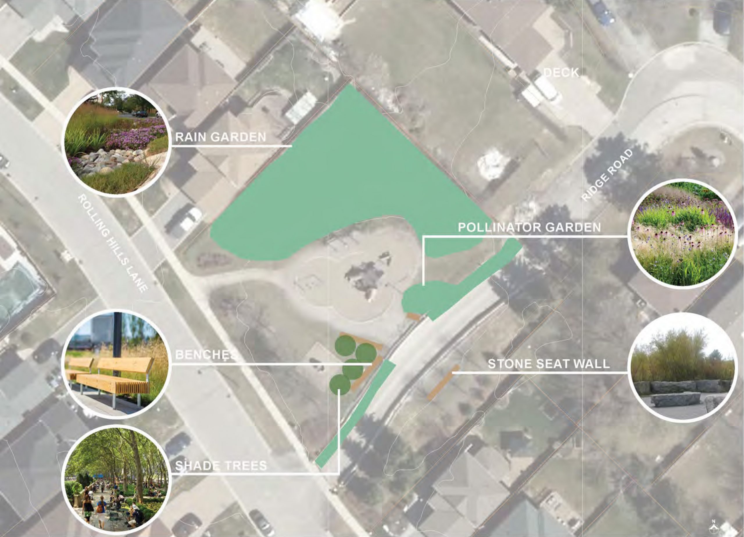
Heritage Hills Parkette is a node along the Memory Lane Walk. The key experiences that this node offers include intergenerational placemaking opportunities, given the presence of a mix of families and seniors in this area, as well as some nature interpretation.
The recommended design objectives for this site include:
- Installing resting stations to support walkability
- Planting trees to provide shade and reduce the urban heat island effect
- Depaving sections of the wide pathway and planting native gardens instead to revitalize the space
CONCEPT PLAN
Select image to view full-sized.
ARTIST RENDERINGS
Use arrow buttons to view before and after images. Select Read Now for full-screen view.
Concept design for illustrative purposes only. Detailed design will be completed as part of implementation.
Adam Wallace Memorial Park is a key node along the Harvest Moon Walk. The main experiences that this node offers include community gathering, nature viewing and interpretation, exercise and sports, and citizen science.
The design objectives identified for this site during the West Bolton SNAP planning process include:
- Creating a diversity of functions and experiences in the park across demographics
- Helping to protect the ecologically significant woodlot
CONCEPT PLAN
Select image to view full-sized.

ARTIST RENDERINGS
Use arrow buttons to view before and after images. Select Read Now for full-screen view.
Adam Wallace Memorial Park concept designs by:
University of Toronto’s John H. Daniels Faculty of Architecture, Landscape and Design.
Concept design for illustrative purposes only. Detailed design will be completed as part of implementation.
The unnamed stormwater management (SWM) pond at Harvest Moon Drive and Coleraine Drive is a node along the Harvest Moon Walk. The main experiences that this node offers include meditation and nature appreciation.
The design objectives identified for this site during the West Bolton SNAP planning process include:
- Providing an opportunity for testing best management practices in stormwater management
- Contributing to terrestrial natural heritage targets
- Integrating community functions to create a local destination
CONCEPT PLAN
Select image to view full-sized.

ARTIST RENDERINGS
Use arrow buttons to view before and after images. Select Read Now for full-screen view.
Stormwater Management Pond concept designs by:
University of Toronto’s John H. Daniels Faculty of Architecture, Landscape and Design.
Concept design for illustrative purposes only. Detailed design will be completed as part of implementation.
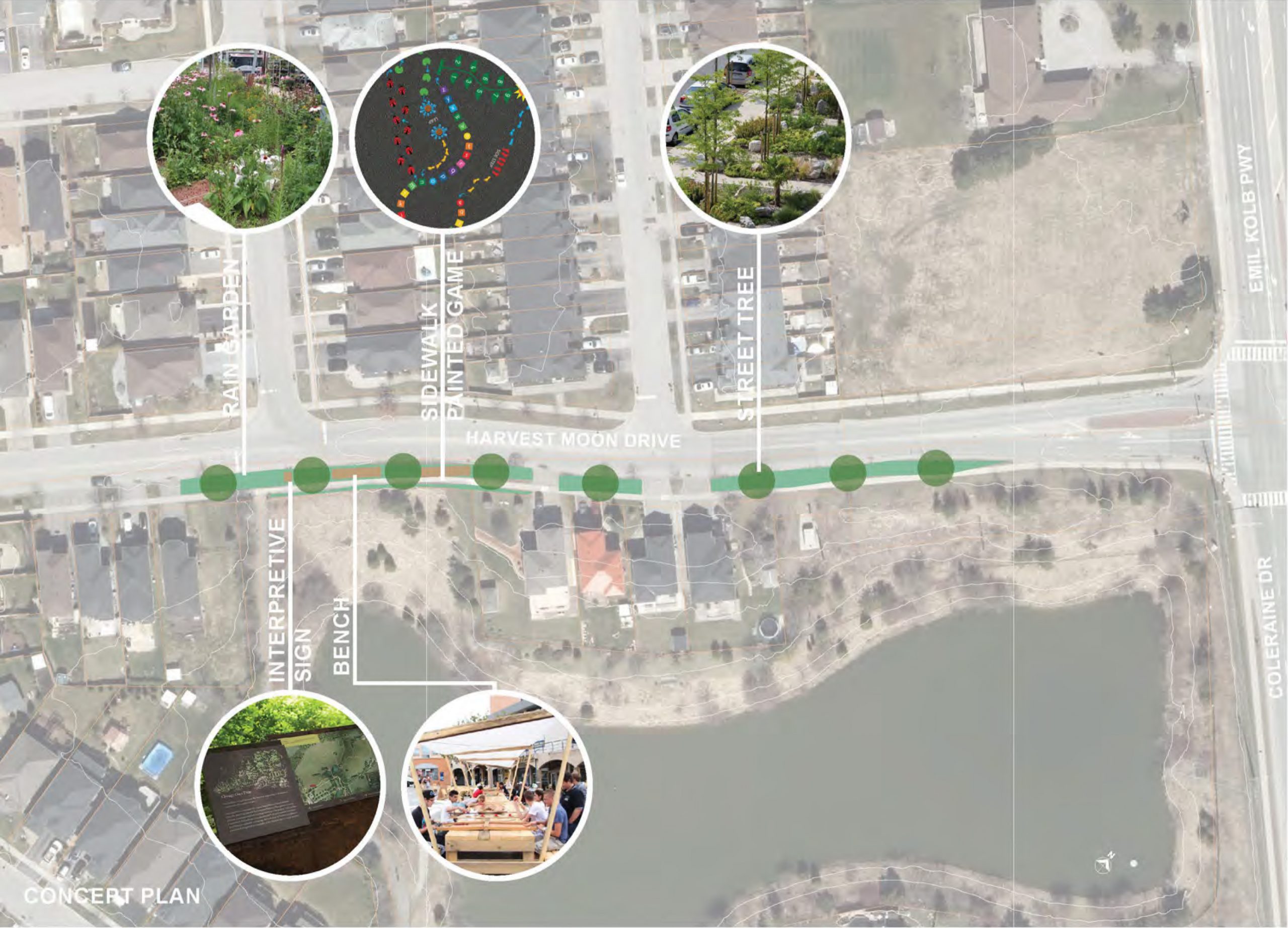
Harvest Moon Drive is a key road through this section of the West Bolton SNAP study area. The area where the road intersects with Cedargrove Road and the entrance to the stormwater pond was identified as a trail node for the Harvest Moon Walk.
This node will provide family-oriented experiences incorporating activities for children as well as spaces to facilitate social interaction among residents.
The key design objective identified for this site during the West Bolton SNAP planning process is retrofitting Harvest Moon Drive to:
- Improve the pedestrian and cyclist experiences
- Contribute to improved stormwater management in road right-of-ways
CONCEPT PLAN
Select image to view full-sized.
ARTIST RENDERINGS
Use arrow buttons to view before and after images. Select Read Now for full-screen view.
Concept design for illustrative purposes only. Detailed design will be completed as part of implementation.
4. Wayfinding and Interpretation
Signage is a key element of any trail system. Several types of signs were identified to enhance the West Bolton trail system:
- Distance markers
- Etiquette signs
- Exercise signs
- Interpretive signs
- Trail marker trees
- Wayfinding signage


Clockwise from left: Distance marker; Interpretive sign (photo courtesy of Gecko Group); Etiquette sign.
5. Trail Programming
The trail system can be further enhanced and animated by one-off, permanent, and regular initiatives and events that cater to diverse groups of trail users.
Walks and Bike Rides
- Bike rides
- Community walks and walking groups
- Forest bathing and nature meditation
- Trishaws
- Walking school bus and bike train
Special Events
- Cultural events in the parks
- Food programs and events
- Outdoor classes
- Seasonal celebrations
Public Art
- Augmented reality experiences
- Bike racks as public art
- Concrete art
- Sound-based experiences
- Tree carving
- Utility box design competition
Citizen Science
- Monitoring activities
Other
- Intergenerational activities
- Little library or story pod
- Stormwater pond naming competition
- Tree sponsorship program


Clockwise from top left: Community walk and walking groups; Forest bathing and nature meditation; Trishaw (photo courtesy of Cycles Toussaint); Cultural events in the parks; Concrete art; Augmented reality experience.