Welcome to TRCA’s
FLOOD FORECASTING AND WARNING CENTRE
SIGN UP TO GET TRCA FLOOD MESSAGES
Why Does TRCA Issue Flood Messages?
A principal mandate of Toronto and Region Conservation Authority (TRCA) is to reduce the risk to life and damage to property caused by flooding.
We do this by providing local agencies and the public with notice, information, and advice so that they can respond during severe rainfall events with the potential for flooding, and during flood-related emergencies.

When Does TRCA Issue Flood Messages?
A flood is an overflow or inundation that comes from a river or other body of water and causes or threatens damage.
Within a riverine system floods are a natural process that occurs as the result of relatively high flow of water overtopping the channel within a valley system.
TRCA operates a Flood Forecasting and Warning Program that monitors weather forecasts and watershed conditions on a continuous basis and issues flood messages when conditions warrant.
Flooding can also occur next to large bodies of water, such as Lake Ontario, and inundate low-lying areas along the shoreline. TRCA also issues messages when water levels reach critical high levels along the Lake Ontario shoreline.
What Kinds of Flood Messages Does TRCA Issue?
If flooding is possible or about to occur, TRCA issues flood messages to municipalities, local agencies, school boards, the media, and members of the public who subscribe.
TRCA issues the following types of messages*:
WATERSHED CONDITIONS STATEMENTS
Water Safety: High flows, unsafe channel banks, melting ice or other factors that could be dangerous for recreation. Flooding is not expected.

Flood Outlook: Early notice of the potential for flooding based on weather forecasts calling for conditions that could lead to high runoff and cause ice jams or lakeshore flooding.

FLOOD WATCH
Flooding is possible in specific watercourses or municipalities. Municipalities, emergency services, and individual landowners in flood-prone areas should prepare.

FLOOD WARNING
Flooding is imminent or already occurring in specific watercourses or municipalities.

LAKE ONTARIO SHORELINE FLOOD MESSAGES
- Lake Ontario Shoreline Conditions (Yellow)
- Lake Ontario Shoreline Flood Watch (Orange)
- Lake Ontario Shoreline Flood Warning (Red)


Lake Ontario Shoreline messages are similar in category to riverine flood messages, but are only applicable to the Lake Ontario shoreline areas within TRCA’s jurisdiction.
They are issued when critical high water levels and waves are forecasted, imminent, or occurring on Lake Ontario, which could result in shoreline flooding and/or erosion.
The International Lake Ontario St. Lawrence River Board (ILOSRB) is responsible for the regulation of outflows from Lake Ontario, and also for providing forecasts. Learn more.
SIGN UP TO GET TRCA FLOOD MESSAGES
*Common flood message terminology has been developed by the provincial Flood Forecasting and Warning Committee (PFFWC) and is documented in the provincial flood forecasting and guidelines. Watershed conditions statements, flood watches, and flood warnings are the standard flood messages used in Ontario by all conservation authorities. Common terminology is essential to reduce confusion and to facilitate external organizations with conveying consistent flood messages with other weather statements and warnings.
Flood Risk Management at TRCA
Flood risk management activities at TRCA encompass all phases of emergency management.

PREVENTION & MITIGATION
1. Limiting Exposure to Risk
- Implementing TRCA’s regulations and policies
2. Reducing Risk
- Operating a Flood Forecasting and Warning program
- Operating and maintaining flood control infrastructure
- Creating a flood mitigation strategy for vulnerable areas
- Implementing remedial works projects
3. Understanding the Risks
- Flood plain mapping (hydraulics), climate and watershed data (stream flow and rain gauge network), watershed response (hydrology), and potential for climate change
4. Documenting the Risks
- Identification of flood vulnerable areas, post flood event documentation.
PREPAREDNESS
- TRCA’s Flood Contingency Plan
- Emergency Plans
- Emergency Operations Centre
- Training
- Public Education
RESPONSE
- Provide Flood Forecasting and Warning (issue flood messages)
- Operate flood control infrastructure
- Communicate information and advice
- Data management
RECOVERY
- Flood event documentation and lessons learned
- Storm analysis
- Support municipal recovery
Contingency Planning
The responsibility for dealing with flood contingency planning in Ontario is shared by municipalities, conservation authorities, and the Ministry of Natural Resources and Forestry on behalf of the province.
As with all emergencies, municipalities have the primary responsibility for the welfare of residents, and should incorporate flood emergency response into municipal emergency planning. Learn more about roles and responsibilities for flooding.
TRCA’s Flood Contingency Plan is intended for all public officials and agency staff likely to play a role in prevention, mitigation, preparedness, response, and recovery pertaining to flood events.
The Flood Contingency Plan provides general information on the Flood Forecasting and Warning program for each conservation authority within the Greater Toronto Area (GTA), as well as specific information and contacts for municipalities within TRCA’s jurisdiction.
Read TRCA’s Flood Contingency Manual
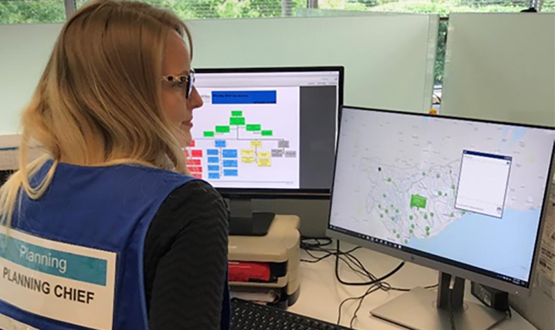
TRCA’s Flood Forecasting & Warning Team
TRCA’s Flood Forecasting and Warning Program staff are responsible assessing and monitoring for floods 24/7. Weather and watershed conditions information is used to assess the potential for flooding.
When spring melt or severe storms are anticipated, the Flood Forecasting and Warning staff Duty Officer and Chief Flood Duty Officer estimate the severity, general location, and approximate timing of possible flooding, and provide local advice and guidance related to the flood risk to municipalities and local agencies.
Key personnel include:
FLOOD DUTY OFFICERS
TRCA’s Flood Duty Officers (FDOs) monitor the watershed and weather conditions using a number of sources, including TRCA’s real-time gauging network, which shows precipitation amounts and water level readings across the jurisdiction.
CHIEF FLOOD DUTY OFFICER
The Chief Flood Duty Officer (CFDO) is tasked with supporting the FDO, especially with flood event operations and circulating information to TRCA staff.
HYDROMETRIC TECHNOLOGIST
Hydrometric Technologists or staff are responsible for maintaining TRCA’s hydrometric network of rain and stream gauges, as well as climate stations. During floods, they may go out into the storm to conduct site visits to investigate and document conditions.
DAM OPERATOR
Dam Operators (for TRCA’s operable dams) are available 24/7 to operate dam gates if requested. During flood situations, dam operators carry out multiple dam operations, monitor dam safety, report reservoir levels, and activate emergency back-up systems if required.
River Watch
These staff support the Flood Forecasting and Warning Program by undertaking observations of water level/flow/ice conditions during or following an event, as well as location inspections of reported flooding.
As part of the TRCA’s Flood Forecasting and Warning Program, staff are also trained to utilize the Incident Management System (IMS), which is a tool that provides a standard framework for responding to emergencies, including managing an Emergency Operations Centre.

TRCA’s Flood Monitoring & Real-Time Gauging
In order to issue timely flood warning messages, TRCA Flood Duty Officers require access to current water level and precipitation amounts so they can determine the extent of potential flooding.
TRCA has constructed a network of real-time stream and rain gauges to provide up-to-date and accurate data for the Flood Forecasting and Warning Program.
TRCA’s gauges have been strategically placed throughout the jurisdiction in locations with known flood risk.
Day-to-day monitoring and operation of TRCA’s flood monitoring locations are conducted by TRCA’s Flood Infrastructure and Hydrometrics team. The team provides routine maintenance, flood event on-site inspections, and calibration of equipment.
TRCA uses three main types of gauges:
1. PRECIPITATION GAUGES
A precipitation gauge is an instrument used to gather and measure the amount of rainfall (precipitation) over an area in a specific period of time.
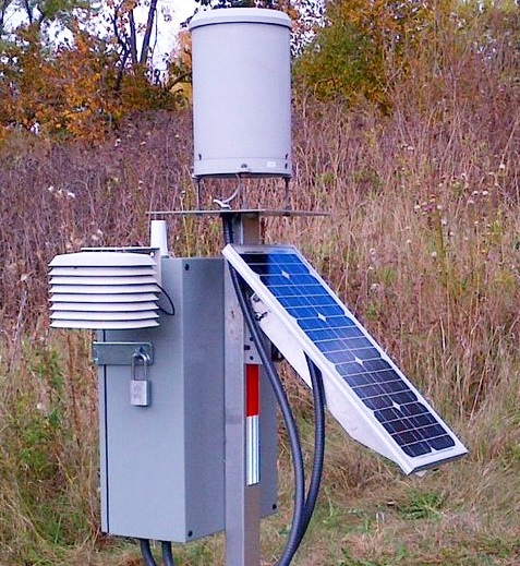

The precipitation network consists of three-season tipping bucket gauges and four-season gauges.
Three-season gauges are in place for the spring, summer and fall, while four-season gauges are in place all year and can record during the winter months.
2. STREAM GAUGES
Stream gauging is the process of measuring the water level or flow at a particular point along channels within a watershed.
Measurements are taken using portable equipment and permanent monitoring stations.
Stream gauges measure water levels every 15 minutes and transmit the data back to TRCA.
If predetermined water level thresholds are exceeded, the Flood Emergency Management group receives an alarm through email and text.
Predetermined water level thresholds are based on a number of factors including historical knowledge and interpretation of TRCA’s flood plain mapping and associated hydraulic models.


3. REAL-TIME CAMERAS
Camera views have also been added to the gauging network as another method to confirm weather and watershed conditions at specific locations.
Currently TRCA operates three stream gauge and three dam reservoir cameras within the jurisdiction.


Above left: Don at Todmorden Mills stream gauge camera; above right: Milne Dam camera
Flood Control Infrastructure
TRCA’s 12 dams, six dikes, and nine flood control channels are maintained and operated by TRCA Flood Infrastructure staff on a 24-hour-a-day basis when required, based on weather patterns, and watershed conditions.
TRCA flood structures span across all our watersheds. While some dams were constructed and used for flood control, others are used primarily for recreation.
Learn More About TRCA Flood Control Infrastructure
TYPES OF FLOOD CONTROL
- A dam is a barrier constructed to hold back, forward, or divert water.
- A reservoir is an enlarged natural pond, created using a dam to store water.
- Flood control channels are engineered watercourses that are designed to maximize the amount of flow. Flood control channels are typically lined with concrete or stone.
- A flood control dike is a long wall or embankment built to prevent flooding from a river course. Dikes can also be called berms.
Another type of flood control is the flood protection landform (FPL), which is a non-structural measure made of earth.
Landforms are similar to dikes, since they are man-made barriers placed beside watercourses to provide flood protection.
Unlike traditional dikes, however, landforms are built on a much larger scale and to a significantly higher standard.
TRCA’s dams have several purposes, including flood control, recreation, and habitat control.
Many TRCA dams are small, historical structures that used to supply power for grain milling and sawmills.
TRCA dams built for flood control protect against flooding by collecting and holding water in our reservoirs. After the storm has passed, the gates are opened to create storage for the next storm.
OPERATING DAMS DURING FLOOD EVENTS
TRCA Dam Operators are available to operate TRCA dams 24/7. During flood events, dam operators have many responsibilities, including:
- Availability to operate dams any time of day or night
- Monitoring the dam to ensure the structure is safe
- Report reservoir levels to TRCA’s Flood Duty Officers
- Activate emergency back-up systems, if required
FOR MORE INFORMATION
- Learn more about TRCA’s dams and water control structures.
- Learn how to stay safe around dams.
- Check current water levels.
Active Remediation Studies
TRCA flood infrastructure requires maintenance so that it can fulfill its function, and so that public safety standards can be maintained. Learn about ongoing and upcoming maintenance and remedial projects.
QUICK LINKS


