Use the information on this page to help you understand and prepare for flooding if you live in the community of Unionville, in the City of Markham.
1. KNOW YOUR RISKS
Do You Live in an Area at Risk of Riverine Flooding?
USE OUR MAP VIEWER TO FIND OUT.
If you’re not sure whether your home is in a floodplain, use Toronto and Region Conservation Authority’s (TRCA) map viewer to find out. Just enter your address in the search bar.
If your home lies within the blue shaded areas (as shown below), you are within the floodplain and could be at risk of flooding.
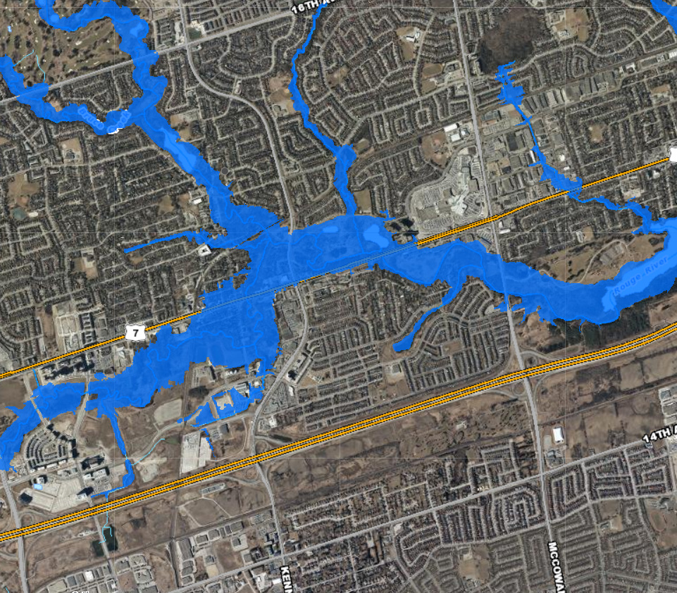
Understanding Flood Risk in Unionville
The Unionville cluster is located within the Rouge River watershed, between Warden Avenue and Markham Road, and bounded north and south from 16th Avenue and Highway 407. The Unionville community is also the location where two subwatersheds (Bruce and Middle-Beaver Creeks) join the main Rouge River.
Flooding occurs due to the low-lying nature of areas along the watercourse upstream of the CN railway and conveyance limitations associated with the CNR crossing, in addition to historical development within the floodplain.
In the past, ice jams have occurred in the vicinity of Main Street in Unionville, south of Carlton Road to Victoria Avenue, and upstream of Kennedy Road. High flows also occur south of Toogood Pond and Dam.
The Unionville cluster is designated a Special Policy Area (SPA): an area within a community that has historically existed in the floodplain, and where site-specific Provincial policies are intended to provide for the continued viability of existing uses.
UPDATE: Unionville Special Policy Area Boundary Review
In 2019, TRCA updated floodplain mapping for the Rouge Watershed in the Unionville area
The Rouge River Floodplain Mapping Update included a comprehensive floodplain mapping update of approximately 103 floodplain map sheets within the municipalities of the City of Toronto, City of Richmond Hill, City of Markham, City of Pickering, and the Town of Whitchurch-Stouffville.
The City of Markham conducted a boundary review of the Unionville SPA based on TRCA’s updated floodplain mapping. LEARN MORE.
What Types of Flooding Can Affect Unionville Residents?
Did you know that there are several types of flooding? Different levels of government are responsible for different types of flooding. To find out who to contact during a flood, see BE PREPARED.
- River (or riverine) flooding occurs when the water levels of rivers rise, overflowing their banks. Reducing riverine flood risk is under the mandate of Conservation Authorities like TRCA.
- Urban (or pluvial) flooding consists of street flooding, basement flooding, and flooding of other low-lying areas due to the overflow of local drainage systems. Municipalities are responsible for managing this type of flooding.
Flooding in Unionville Can Happen at Any Time of Year
| WINTER: A rise in the water level or a thaw can break winter ice into large chunks, which can lead to jams behind structures such as bridges, culverts and crossings. | |
| SPRING: Rivers and streams can experience high flows in the early spring, as rising temperatures melt the winter’s accumulation of snow, causing water levels to rise. | |
| SUMMER: Intense, localized downpours from thunderstorms can quickly lead to flooding in smaller creeks. | |
| FALL: Large wet weather systems, including tropical storms such as Hurricane remnants (like Hurricane Hazel in 1954), can last for several days. Prolonged and heavy precipitation, on top of already saturated soils, can cause rivers to rise. |
How Will I Know If Flooding In Unionville Is Forecasted?
- TRCA operates a Flood Forecasting and Warning Program. If flooding is possible or about to occur, TRCA issues flood messages to designated individuals within municipalities, local agencies, school boards, the media, and members of the public who self-subscribe. LEARN MORE

- TRCA maintains a network of river and rainfall gauges. Get real-time gauging information.
2. BE PREPARED
When it comes to flood preparedness, everyone — homeowners, landlords, renters, and condo owners — has a role to play. You can take steps to prepare; just select a category below to find out more.
3. STAY INFORMED
Use the following sources to stay informed during a flood:
| • Check your local weather online, or on radio or television before you leave the house. |
| • Check Environment Canada’s public weather alerts |
| • Sign up to receive TRCA flood messages |
| • Check your local municipal and public transit social media links (below). |
Social Media Alerts and Notices
Additional Resources
| • Emergency Management Ontario |
| • Ontario’s Emergency Management and Civil Protection Act: Disaster Recovery Assistance for Ontarians |
• Public Safety Canada:
|
| • Flood Smart Canada – Created in partnership with the Insurance Bureau of Canada, this resource is designed to help Canadians better prepare for flooding. |
| • Electrical Safety Authority: Flood Safety Information |
| • Intact Centre on Climate Adaptation: Flood Protection Resources |
| • Institute for Catastrophic Loss Reduction: Protect Your Home from Basement Flooding |
Information About Flood Insurance