About TRCA’s Flood Control Infrastructure
Toronto and Region Conservation Authority (TRCA) manages 12 dams, 9 flood control channels, and 6 dikes across the Greater Toronto Area.
TRCA’s two largest operable dams, G. Ross Lord Dam and Claireville Dam, require a 24/7 on-call dam operator.
These dams are checked daily by the operator and are frequently inspected and tested by TRCA’s Flood Infrastructure and Hydrometrics staff.

Claireville Dam
In addition, TRCA’s Flood Infrastructure staff maintains a number of small dams, dikes, and flood control channels.
While these structures are not operated during flood events, it is important to note that they are flood control infrastructure and therefore have similar risks associated with them. Safety precautions should be taken around these structures.
TRCA Flood Control Structures – Toronto
G. Ross Lord Dam
G. Ross Lord Dam was constructed in 1973 to provide flood control for the West Don River. The dam operates in conjunction with downstream flood control channels to reduce the risk of flooding to flood vulnerable communities.
G. Ross Lord Dam is an earthen embankment dam with two concrete control structures. The first control structure consists of two low level gates used to draw the reservoir down after a rain event. The second control structure has two large radial arm gates for use during extreme storm events.
LEARN MORE ABOUT G. ROSS LORD DAM


G. Ross Lord Dam
Yonge-York Mills Channel
This flood control channel was constructed between 1956 and 1968 to provide flood protection for the community of Hoggs Hollow in conjunction with the G. Ross Lord Dam and reservoir.
Location: Wilson Avenue and Yonge Street to Rosedale Golf Club, Toronto
Sheppard Channel
The channel was originally designed and constructed in the late 1960’s to facilitate the construction of the Sheppard Avenue bridge and provide flood protection to the residents adjacent to Don River Boulevard.
Location: Sheppard Avenue West and Bathurst Street, Toronto

Yonge-York Mills Channel

Sheppard Channel
Black Creek Dam
Black Creek Dam is located on the Black Creek tributary of the Humber River, upstream of the river crossing at Jane Street. The dam was constructed in 1960 to reduce peak flood flows on Black Creek.
Location: Southeast of Jane Street and Sheppard Avenue, Toronto

Black Creek Dam
Scarlett Road Channel
The Scarlett Road Channel was designed and constructed in 1967 to provide protection for public utilities against erosion and provide flood water conveyance of Black Creek through Alliance Road and the Rockcliffe Corridor.
Location: Weston Road to west of Scarlett Road, Toronto
Black Creek Channel
Black Creek Channel was constructed in the 1960s to provide flood protection to the Jane Street and Wilson area.
Location: Jane Street at Wilson Avenue to Queens Drive, Toronto

Scarlett Road Channel

Black Creek Channel
West Don Flood Protection Landform
The West Don Lands area of downtown Toronto lies within the flood plain of the Don River. Before revitalization and development could occur, the area required flood mitigation. In 2015 an oversized dike, designed to withstand all failure conditions, was constructed to wrap around this area.
The West Don Flood Protection Landform removes flood risk and allows the redevelopment of this area in the form of residential and commercial buildings.
Location: West side of Don River, upstream of Lake Shore Boulevard

TRCA Flood Control Structures – Peel Region*
*Within TRCA’s jurisdiction.
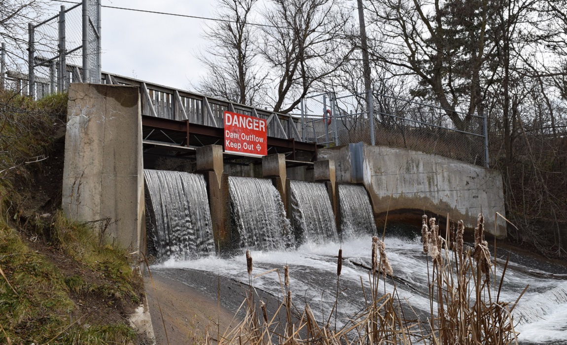
Claireville Dam
Claireville Dam was constructed in 1963 to provide flood control for the West Humber River. The dam has earth embankments with a concrete control structure. The spillway and outlet works consists of five radial arm gates.
Location: Finch Avenue West and Highway 427, Brampton
LEARN MORE ABOUT CLAIREVILLE DAM


Claireville Dam
Palgrave Dam
Palgrave Dam was originally constructed in the 1850s to power a mill. It was acquired by TRCA in 1979, and restored in 1983. The construction of the dam led to the creation of Palgrave Pond, located on the east side of Highway 50.
Although no longer in operation as a mill dam, it remains intact to preserve the pond for its local historical and heritage value.
Location: Highway 50 and Pine Avenue, Caledon

Palgrave Dam
Glen Haffy East Dam and West Dam
The Glen Haffy West and East Dams were constructed in the late 1950s to create two small trout ponds downstream of the Glen Haffy Conservation Park fish hatchery. The ponds are stocked with rainbow trout and are a popular fishing destination.
Location: South of Mono Mills and Highway 9 on Airport Road, Caledon
Glen Haffy Extension Upper and Lower Dams
TRCA owns two recreational dams in the Glen Haffy Conservation Area Extension Lands Property. The dams create two ponds that were used for fly-fishing in the past.
Location: Centreville Creek Road south of Highway 9

Glen Haffy Dam

Glen Haffy Extension
Bolton Dike and Channel
The Bolton dike was built along the south bank of the river to prevent flood water from entering the Bolton core. It works in conjunction with a diversion channel to maximize flood conveyance during high flow events.
Location: Highway 50 and King Street, Bolton

Bolton Dike

Bolton Channel
Brampton Channel
Built in 1952, the Brampton Channel was designed to provide protection from 100-year flood flows (1% chance of occurring in a given year) in downtown Brampton.
Location: Church Street to south of the CN Rail line, Brampton

Brampton Channel
Etobicoke Creek Dike
This dike extension was constructed in 1967 to protect homes on Meadowland Drive and the Brampton Shopping Plaza from flood flows.
Location: Centennial Park, Brampton
Tyndall Flood Wall
In 1992, after channel alterations resulted in frequent severe flooding and evacuations of a nursing home in the vicinity during the 1980s, TRCA undertook flood control works to decrease flood risk from higher frequency events.
Location: 1060 Eglinton Avenue East, Mississauga
Mimico-Malton Channel
Constructed in 1972, the Mimico-Malton Channel was designed to prevent flooding of commercial and residential development within the flood plain.
Location: Airport Road and Derry Road East, Mississauga

Etobicoke Creek Dike

Tyndall Flood Wall

Mimico-Malton Channel
TRCA Flood Control Structures – York Region*
*Within TRCA’s jurisdiction.
Milne Dam
Milne Dam was constructed in 1969, replacing an older dam that had been severely damaged during Hurricane Hazel.
Location: Southwest of Highway 7 and Markham Road, Markham


Milne Dam
Stouffville Dam
Stouffville Dam was constructed in 1969 to to provide 100-year flood protection to the Town of Whitchurch-Stouffville.
Location: Millard Street at Stouffville Conservation Area, Stouffville
LEARN MORE ABOUT STOUFFVILLE DAM
Stouffville Channel
Stouffville Channel was constructed in 1980 to protect downtown Stouffville from flooding.
Location: Stouffville Creek at Main Street, Stouffville

Stouffville Dam

Stouffville Channel
Oak Ridges Channel
Oak Ridges Channel was constructed in 1980 to protect residential homes in the area from flooding.
Location: Parker Avenue and the Humber River, King City
Woodbridge Channel
Built in 1962, Woodbridge Channel was designed to decrease erosion and provide storm water conveyance through the Woodbridge flood plain lands.
Location: Islington Avenue and Highway 7, Woodbridge

Oak Ridges Channel

Woodbridge Channel
TRCA Flood Control Structures – Durham Region*
*Within TRCA’s jurisdiction.
Secord Dam
Secord Dam was originally constructed in 1922 to provide hydro power to a sawmill, which operated until the 1950s. The dam and property were acquired by TRCA in 1997.
Location: 3rd Concession and Secord Road, Uxbridge


Secord Dam
Osler Dam
Osler Dam was built in 1934 as a private fishing pond. TRCA purchased the property in 1991.
Location: Northwest of Concession 9 and Sideline 4, Pickering

Osler Dam
Ajax Dike
The Ajax Dike, constructed in 1984, extends for approximately 325 metres.
Location: Church Street South extending north from near Mill Street, Town of Ajax
Pickering Dike
The Pickering Dike, constructed in 1985, extends for approximately 1,150 metres.
Location: Kingston Road and Church Street, City of Pickering
TRCA has undertaken a Conservation Ontario Class Environment Assessment (EA) to examine rehabilitation options for the Pickering and Ajax dikes. LEARN MORE

Ajax Dike

Pickering Dike
QUICK LINKS


