June 20, 2025, Toronto, ON – As summer arrives, so does the risk of severe thunderstorms that can bring heavy rainfall, strong winds, lightning, and hail. Toronto and Region Conservation Authority (TRCA) is reminding residents across the Greater Toronto Area (GTA) to prepare for the possibility of flooding during severe weather.
To stay informed when it matters most, all residents are encouraged to sign up for TRCA flood messages at trca.ca/floodmessages.
A Look Back: Summer 2024 Severe Thunderstorm Events
In 2024, the GTA experienced one of the wettest summers in recent memory. June and July brought over 300 mm of rain, nearly triple the usual amount.
On July 16, severe thunderstorms hit the cities of Mississauga and Toronto. The severity of rainfall ranged from as little as 8 mm to a rare 102 mm, highlighting the localized nature of the storm.
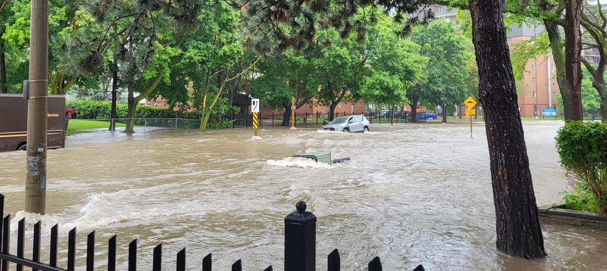
The largest amount of rain was recorded near Little Etobicoke Creek by TRCA’s Rathwood precipitation gauge station. For context, this rain gauge recorded the equivalent of a full bathtub of water for every square meter in just one hour, overwhelming rivers and urban drainage systems and causing flash flooding.
August 17-18 saw more severe storm impacts, including a record-breaking 128.3 mm of rain at Pearson Airport and flooding across TRCA watersheds, including the Humber River, Don River, Rouge River, and Etobicoke Creek.
These events highlight how quickly storms can develop and the importance of being prepared.
Rain is considered heavy at just 10 mm per hour, but during the intense July and August 2024 thunderstorms, rainfall rates recorded at some locations reached an extreme 50 to 80 mm per hour. That kind of downpour can quickly overwhelm drainage systems and rivers to trigger flash flooding with little warning.
What Causes Severe Summer Storms?
Severe weather in the GTA can be driven by:
- Thunderstorms: Rapidly developing systems caused by unstable atmospheric conditions result in heavy rain, hail, lightning, strong winds, and sometimes even tornadoes.
- Tropical Systems: Ontario occasionally experiences the effects of post-tropical storms or hurricane remnants, which are associated with intense rainfall and very strong winds. The Atlantic hurricane season typically runs from June 1 to November 30 each year.
Understanding the Flood Risk
TRCA’s watersheds can be “flashy,” meaning water levels can rise quickly after intense rainfall, particularly in urban areas with hard surfaces, such as concrete, that prevent water absorption.
These conditions can lead to localized flooding within minutes, with little to no warning.
Summer Flood Safety Tips
To help keep yourself and your family safe this summer:
- Avoid trails, rivers, and water-based activities during and immediately after it rains.
- Never walk or drive through flooded roads or fast-moving water.
- Stay up to date. Use weather alerts from local media or mobile apps such as WeatherCAN from Environment Canada.
- Follow all signs indicating road, park, and trail closures due to flooding.
- Follow all directions from emergency responders if evacuation is advised.
- Always call 911 in case of immediate danger to life.
How TRCA Helps Protect Communities
TRCA operates a Flood Forecasting and Warning Program that monitors weather and watershed conditions daily, which includes:
- A TRCA Flood Duty Officer is on-call to assess flood risks when significant rainfall is expected.
- TRCA flood messages are issued to municipalities, emergency responders, and public subscribers. Sign up to receive TRCA flood messages at trca.ca/floodmessages and stay informed during the storm season.
- When severe weather is possible, TRCA uses radar, forecasting tools, and real-time data from its Flood Monitoring Gauging Network to inform the issuance of flood messages. Visit trca.ca/floodmonitoring for real-time updates on water levels and rainfall.
Stay safe this summer! Know your risks, be prepared, and stay informed.
Visit trca.ca/flood to learn more | Follow us on X @TRCA_Flood