Living Downstream of Palgrave Dam: Flood Safety
1. KNOW YOUR RISKS
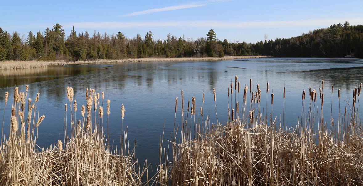
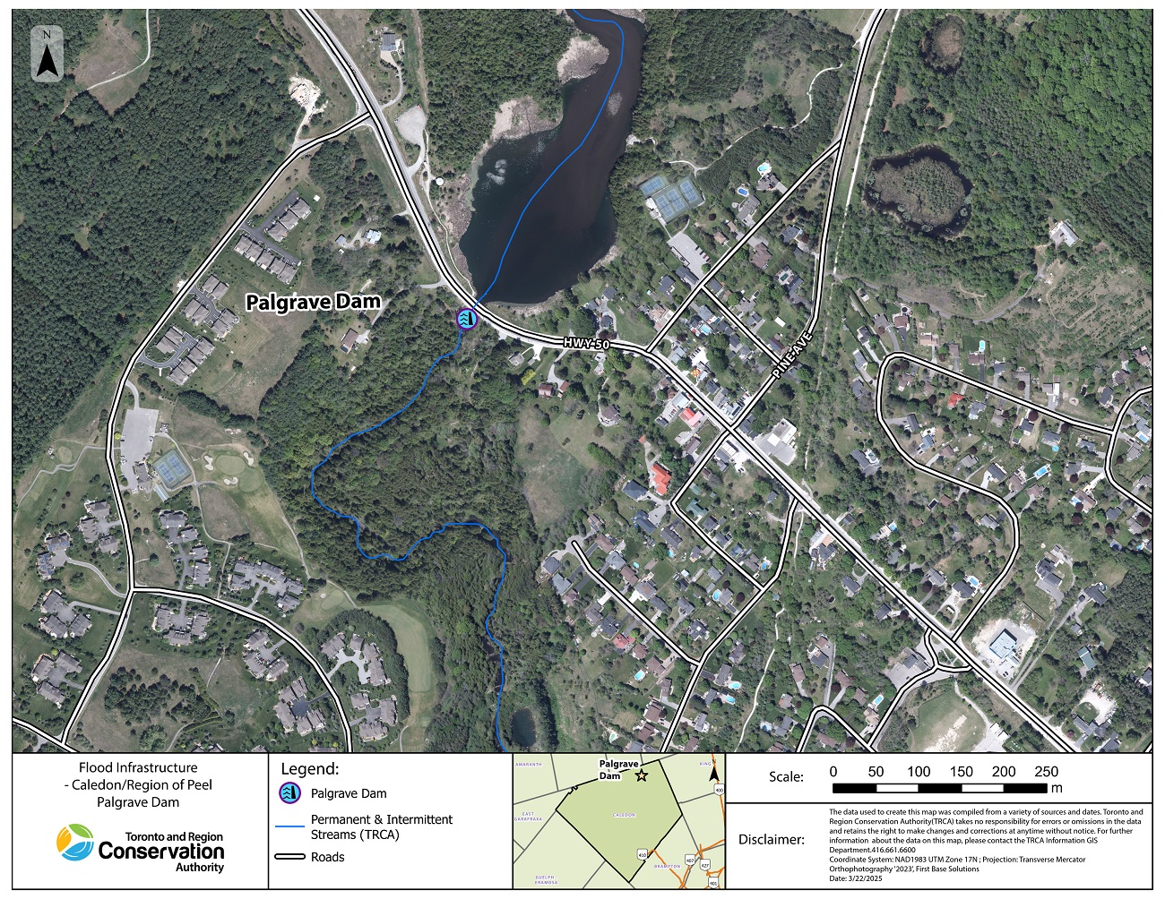
About Palgrave Dam
The Palgrave Dam in Caledon, owned and managed by TRCA, was first built in the 1850s to generate power for a sawmill.
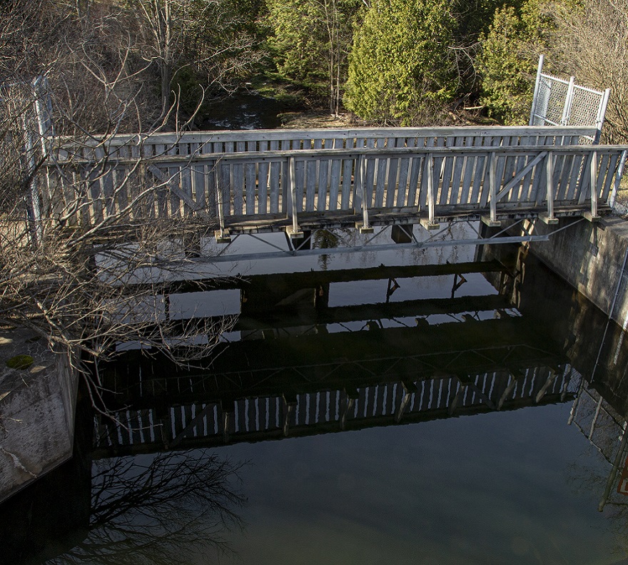
Although no longer in operation as a mill dam, it remains intact to preserve the pond for its local historical and heritage value.
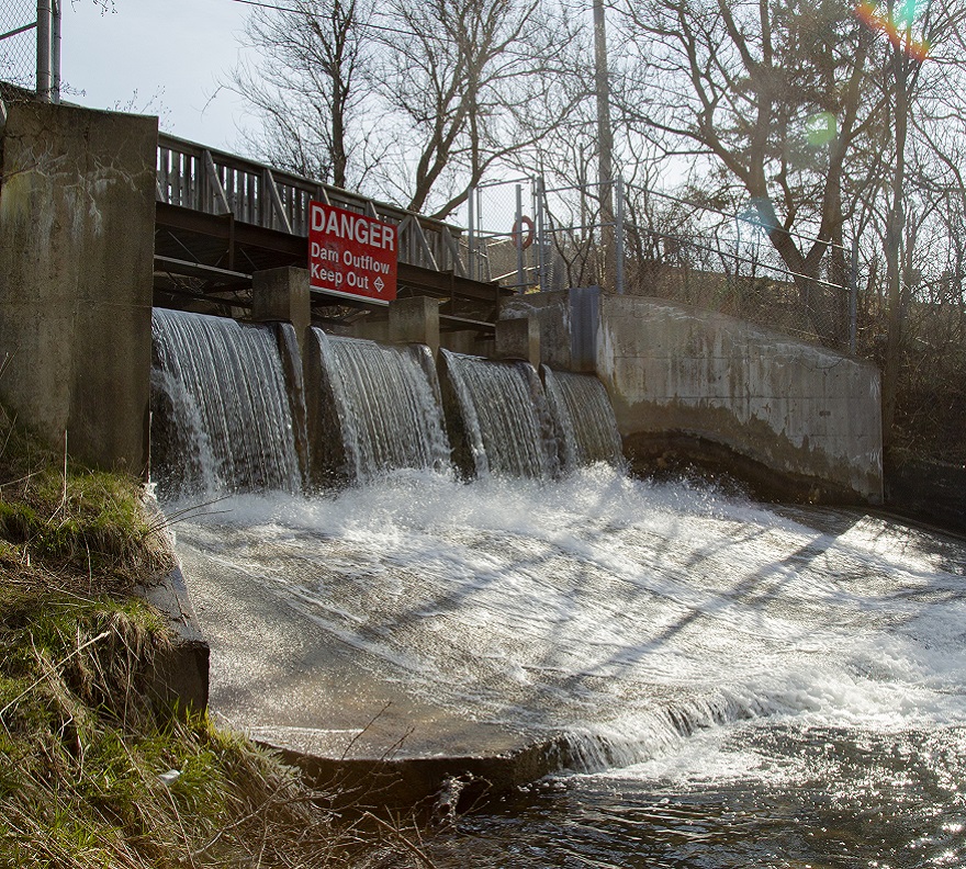
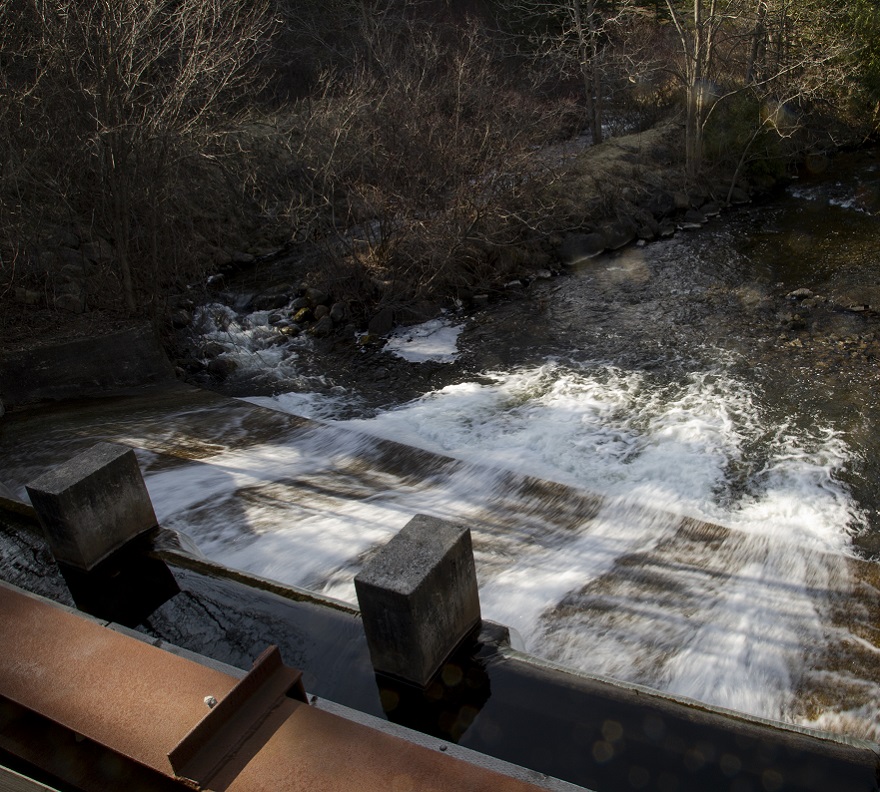
This dam does not provide flood control, but has significant risk to downstream communities if the dam breaks or overtops.
Palgrave Dam: Map
Select the image below to view the full-sized map.
Palgrave Dam: Quick Facts
- Location: Highway 50 and Pine Avenue, Caledon
- Date of Construction: 1850s, restored in 1983
- Status at Dam: The Palgrave Dam is in fair condition and regularly maintained. It is classified as a very high hazard dam, which refers to the potential impact if the dam were to fail. TRCA continues to invest in studies and preventative maintenance to support its long-term safety.
Learn more about TRCA FLOOD CONTROL INFRASTRUCTURE.
Public Safety
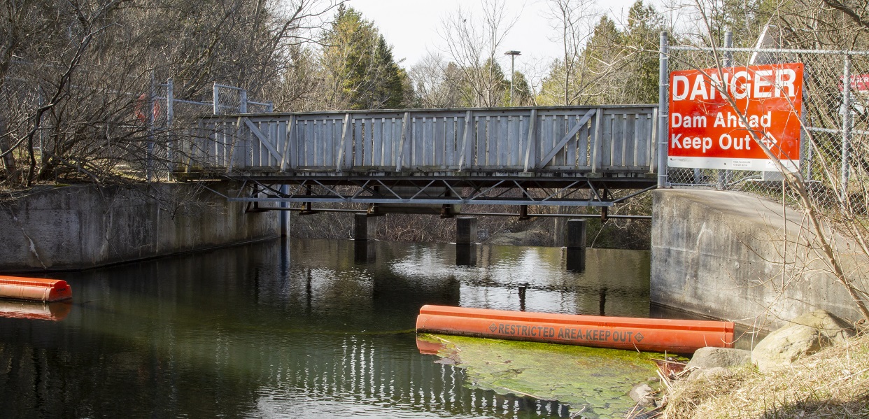
Dams and reservoirs can be very dangerous, especially during and after heavy rainfall or snowmelts. The water near them can be deep and fast-moving. It’s important to stay away from dams and their surrounding areas.
Learn more about DAM SAFETY.
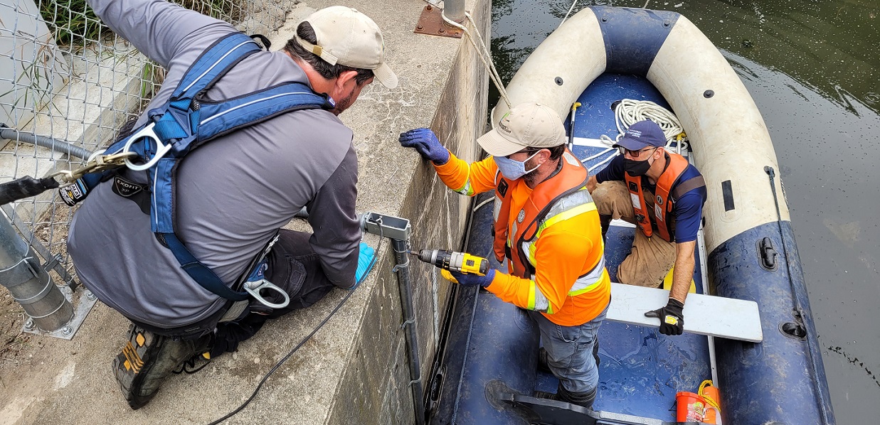
What TRCA is Doing to Improve Dam Safety
- Regular Inspections: TRCA conducts monthly, quarterly, and annual dam inspections to monitor structural integrity and identify maintenance needs.
- Infrastructure Improvements: Ongoing upgrades to dams and flood related infrastructure help to keep dam conditions safe.
- Improved Communication with Municipal Staff: We’ve improved coordination with local emergency management teams to ensure quick, informed decision-making during an event.
- Dam Emergency Plans: We’ve developed dam emergency plans.
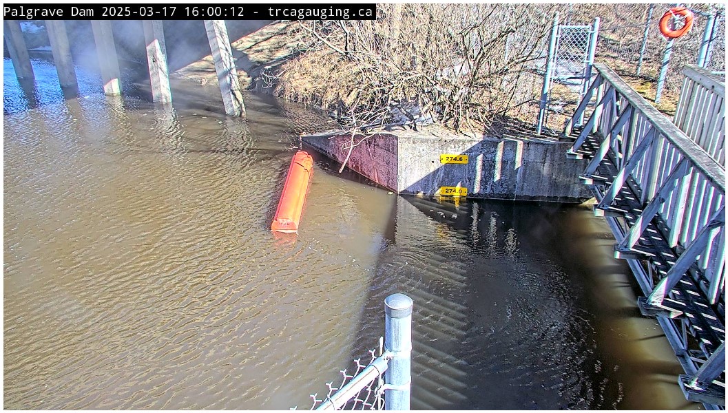
- Additional Monitoring Tools: We installed cameras at key locations to provide real-time monitoring and improve situational awareness during weather events. View trcagauging.ca.
What Types of Flooding Can Affect Residents?
Did you know that there are several types of flooding? Different levels of government are responsible for different types of flooding. To find out who to contact during a flood, see BE PREPARED.
- Riverine flooding occurs when the water levels of rivers rise, overflowing their banks. Reducing riverine flood risk is under the mandate of Conservation Authorities like TRCA.
- Urban or Pluvial flooding consists of street flooding, basement flooding, and flooding of other low-lying areas due to the overflow of local drainage systems. Municipalities are responsible for managing this type of flooding.
Flooding Can Happen at Any Time of Year
| WINTER: A rise in the water level or a thaw can break winter ice into large chunks, which can lead to jams behind structures such as bridges, culverts, and crossings. | |
| SPRING: Rivers and streams can experience high flows in the early spring, as rising temperatures melt the winter’s accumulation of snow, causing water levels to rise. | |
| SUMMER: Intense, localized downpours from thunderstorms can quickly lead to flooding in smaller creeks. | |
| FALL: Large wet weather systems, including tropical storms such as Hurricane remnants (like Hurricane Hazel in 1954), can last for several days. Prolonged and heavy precipitation, on top of already saturated soils, can cause rivers to rise. |
How Will I Know If Flooding Is Forecasted?
TRCA operates a Flood Forecasting and Warning Program to support municipal partners during storm events and fulfill responsibilities delegated by the Ontario Ministry of Natural Resources.
The program provides advice on timing and severity of potential flooding, helping protect lives and property while also educating the public about flood risks.
To help residents stay safe, TRCA provides resources and guidance for flood preparedness. Learn what steps to take before, during, and after a flood by exploring our Emergency Management and Safety Resources.

Sign Up for Flood Messages
In order to provide support to our municipal partners during storm events, TRCA runs a Flood Forecasting and Warning Program.
The program provides advice and warning to municipalities for the forecasted timing and severity of potential flooding events from rivers and streams.
Active flood messages from TRCA can be viewed directly in two ways: on our website or on X.
Real-Time Water Level Information
TRCA has dozens of water level gauges on rivers and streams at important locations throughout the Greater Toronto Area as part of its Flood Forecasting and Warning Program.
Explore real-time reservoir water levels at Palgrave Dam, including the live camera view, at TRCAgauging.ca/PalgraveDam.
2. BE PREPARED
When it comes to flood preparedness, everyone – homeowners, landlords, renters, and condo owners – has a role to play. You can take steps to prepare; just select a category below to find out more.
3. STAY INFORMED
Use the following sources to stay informed during a flood:
| • Check your local weather online, or on radio or television before you leave the house. |
| • Check Environment Canada’s public weather alerts |
| • Sign up to receive TRCA flood messages |
| • Check your local municipal and public transit social media links (below). |
Social Media Alerts and Notices
Additional Resources
TRCA Open House Information Session
In January 2020, Toronto and Region Conservation Authority (TRCA) hosted an open house information session to help residents and businesses in downtown Bolton become better prepared for flood risk. To learn more about riverine flooding in Bolton, just check out the resources from the open house below.
VIEW THE DISPLAY PANELS FROM THE OPEN HOUSE
You can download a PDF copy of the panels, or view the panels using the document reader below. Select Read Now for a full-screen view; select the arrow to the right to advance to the next page.
Useful Links
| • TRCA.ca/Flood |
| • Safety Around Dams |
| • TRCA Flood Forecasting and Warning Centre Page |
| • Ontario Power Generation (OPG) Water Safety |
| • Living Near Dams |
| • Emergency Management Ontario |
| • Ontario’s Emergency Management and Civil Protection Act: Disaster Recovery Assistance for Ontarians |
| • Public Safety Canada: Flood Ready – Tips for overland flooding and first steps to prepare your home |
| • Flood Smart Canada – Created in partnership with the Insurance Bureau of Canada, this resource is designed to help Canadians better prepare for flooding. |
| • Intact Centre on Climate Adaptation: Flood Protection Resources |
| • Institute for Catastrophic Loss Reduction: Flood Resources |
Information About Flood Insurance
Frequently Asked Questions
Where does water going to the dam come from?
Water reaching the dam typically comes from several sources within its watershed area:
- Rainfall and Snowmelt: Precipitation is a major contributor, with rainwater and melting snow running off the land and flowing into rivers, creeks, and streams that feed into the dam’s reservoir.
- Streams and Tributaries: The dam‘s watershed includes various smaller water channels like creeks and tributaries, which carry water from surrounding areas and flow into the main river or reservoir at the dam.
- Runoff from Urban and Rural Areas: When it rains, water runs off streets, fields, and other surfaces within the watershed. This surface runoff collects and channels into streams and rivers that eventually lead to the dam. This location is near the lower end of the Humber River watershed.
How much impact do hard surface developments and permeable surfaces have on flooding?
Hard surfaces do not allow water to infiltrate, so runoff can be seen on paved surfaces even during small rain storms. However, larger rain storms can quickly exceed the infiltration capacity of permeable surfaces and create runoff.
One reason Hurricane Hazel had the impact that it did was because there had been a lot of rain in the days before the Hurricane, which meant that the ground had no more capacity to absorb additional water.
What do I do and how do I know if there is an emergency at the dam?
- If you are in immediate danger, call 911.
- If emergency officials order an evacuation, follow the instructions provided by the first responders.
- There is no set amount of time given for evacuation because delays in information dissemination can occur. For instance, if someone is not tuned into the TV, radio, or other alert systems, they may not receive an immediate evacuation notice. The best course of action is to evacuate as soon as a notification is received. This notification will come from your local municipality.
- A TRCA flood duty officer monitors the weather and stream gauges, allowing them to track changing water levels closely. While some storms, like hurricanes, can be anticipated, other events like thunderstorms are much harder to predict, adding to the importance of quick response upon notification.
- Sign up to receive TRCA flood messages.
Contact Information
Questions? Please contact:
TRCA’s Dam Outreach Project Team
Email: Dams@trca.ca