The Carruthers Creek Watershed Plan (CCWP) will help to guide future decision-making in the watershed.
The development of the CCWP was a collaborative effort between Toronto and Region Conservation Authority (TRCA), the Region of Durham, Town of Ajax, and City of Pickering.
The plan was approved by TRCA’s Board of Directors on September 24, 2021. Durham Regional Council previously endorsed the Carruthers Creek Watershed Plan on June 23, 2021.
You can explore the online, interactive Carruthers Creek Watershed Plan and a map viewer with useful mapping layers on our new Watershed Planning Hub.
EXPLORE THE WATERSHED PLANNING HUB
You can also visit TRCA’s Watershed Plan Implementation Tracking Hub to see how we are putting the Carruthers Creek Watershed Plan into action.
Get More Information
- For technical analyses completed in support of this watershed planning process, see the Watershed Characterization Reports and Scenario Analysis Technical Reports.
- For data files that supported this watershed planning process, see the Carruthers Creek Watershed Plan section on TRCA’s Open Data Portal.
- If you have any questions about the watershed plan, or this process, please email carruthers@trca.ca and a project team member will respond.
Land and Water Acknowledgement
We respectfully acknowledge the lands and waters where we conduct our work are Traditional Territories and Treaty Lands of the Williams Treaties First Nations which includes the Anishinaabe Chippewa of Simcoe (communities of Beausoleil, Georgina Island and Rama), and the Anishinaabe Mississauga (Michi Saagiig) of the north shore of Lake Ontario (communities of Alderville, Curve Lake, Hiawatha, and Scugog Island). These lands are also the Traditional Territories of the Huron-Wendat and the Haudenosaunee and are now home to many diverse First Nations, Inuit and Métis peoples.
Through our work with lands and waters within the greater Toronto Region, Toronto and Region Conservation Authority (TRCA) appreciates and respects the history and diversity of these lands and is grateful to have the opportunity to work and meet in this territory. We are also grateful for the continued work of many First Nations and Indigenous peoples, who are the original and current caretakers of these lands and waters. We humbly acknowledge our responsibility to respect First Nations’ rights, respect Indigenous perspectives, elevate Indigenous voices, and honour our relationship with First Nations and Indigenous peoples.


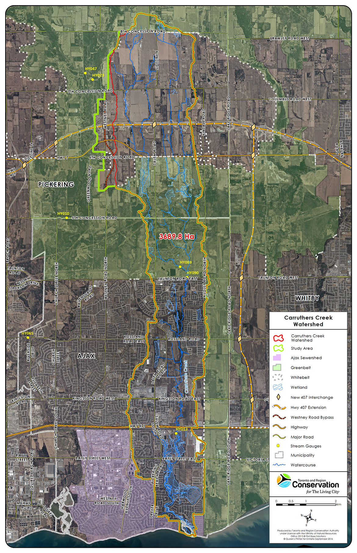
Where is Carruthers Creek Watershed?
Project Timeline
 |
2015-2016 Toronto and Region Conservation Authority (TRCA) scientists conduct field and desktop research to study the watershed’s current conditions. |
|
2016-2017 Field research is analysed by TRCA scientists in technical reports which are reviewed by peers. |
|
Late 2017 – Early 2018 Research is integrated to create an overall assessment of the health of Carruthers Creek watershed. |
|
Early 2018 Stakeholders and the general public are asked for feedback on the original Vision and Management Philosophy. |
|
Mid 2018 Feedback on the original Vision and Management Philosophy is gathered to the end of September. Technical work continues to study and analyse the natural features and functions of the watershed. |
|
Late 2018 Computer models run scenarios regarding potential land use changes to estimate how the watershed’s natural features and functions may change over time. |
|
Late 2018 – Early 2019 Results of scenario models and other analyses are used to formulate Management Recommendations. |
|
Mid 2019 Stakeholders and the general public are asked for feedback on the draft Management Recommendations. |
|
Late 2019 Draft Watershed Plan Completion: Recommendations are finalised based on feedback and the Draft Watershed Plan is complete. |
|
2020 The Draft Watershed Plan is released for public review. |
|
2021 The Final Watershed Plan is approved. |
 |
2021-2031 Implementation, Monitoring, and Evaluation. |
Contact Us
If you have any question about the development of the Carruthers Creek Watershed Plan, please email us at carruthers@trca.on.ca.