
Since spring 2018, Toronto and Region Conservation Authority’s (TRCA) Environmental Monitoring and Data Management team, in partnership with Fisheries and Oceans Canada, has been monitoring fish communities and turbidity conditions in support of the Gibraltar Point Erosion Control Project at the Toronto Islands.
This data will determine baseline environmental conditions before construction begins on the innovative nearshore fish reef, which is designed to halt shoreline erosion at the site while also providing habitat for fish foraging and spawning.

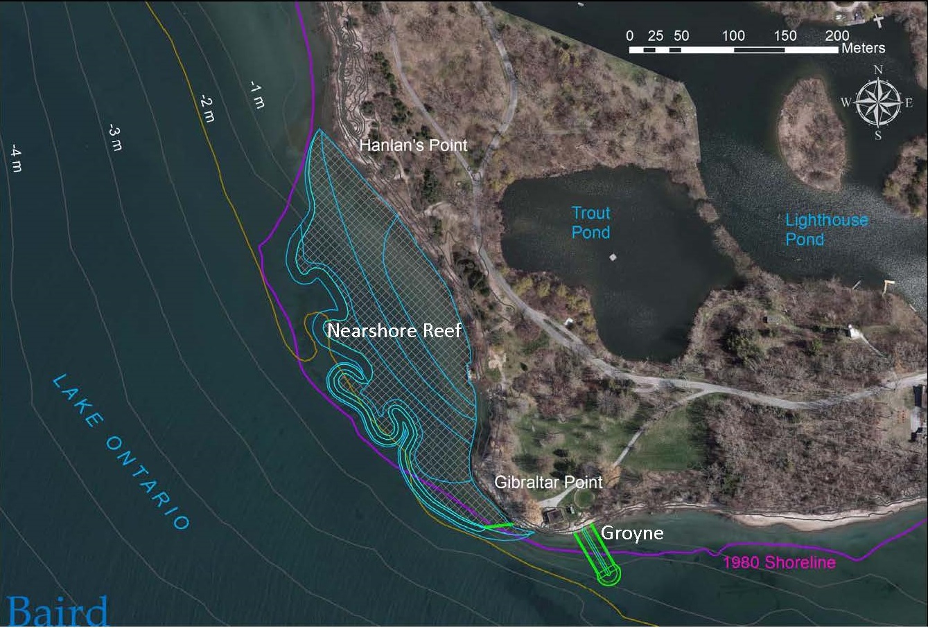
The nearshore reef planned for Gibraltar Point is a great example of how aquatic habitat features can be included in an engineered erosion control design.
The proposed reef will incorporate different stone sizes; the placement of cobble will create sheltered interstitial spaces for invertebrates and small fish, while boulders will provide cover and protection (Reference: Kavanagh and Hoggarth, 2016). Research on the habitat characteristics of Great Lakes fishes (Reference: Lane et al. 1996) indicates that boulder and cobble are desirable habitats for a variety of life stages of coolwater and coldwater species.
The innovation doesn’t just lie in the reef design itself — the project will also lead to new advances in TRCA’s expertise. It will, for example, create an opportunity for TRCA to evaluate how this kind of freshwater nearshore reef habitat functions for native lake fish over time, while also enhancing the organization’s knowledge surrounding aquatic habitat design.
“This project pushes the boundaries on traditional erosional protection design,” says Rick Portiss, TRCA’s Senior Manager, Environmental Monitoring and Data Management. “TRCA is excited to be involved at the ground level of this project, as it provides us with a unique opportunity to monitor lake fish communities using different survey techniques during the pre-construction, construction, and post-construction phases of the project.”
He continues: “The knowledge gained through this active long-term monitoring will be invaluable to building knowledge of Toronto area fisheries and will contribute to the bigger picture of fisheries in Lake Ontario and the Great Lakes. We are pleased to work alongside Fisheries and Oceans Canada collecting important environmental monitoring data for this precedent-setting project.”

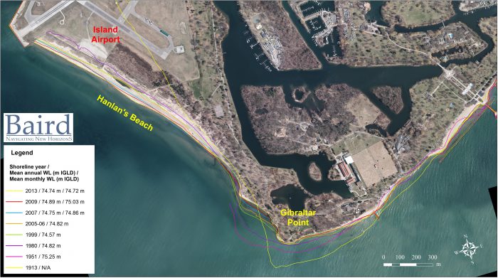
Without this long-term solution to shoreline erosion processes, the unprotected land around Gibraltar Point would continue to be subject to significant erosion, putting places of culture, built infrastructure and natural ecosystems (including an Environmentally Significant Area, an Area of Natural and Scientific Interest and Provincially Significant Wetlands) at risk of complete loss.
The project aims not only to prevent the loss of the island, and mitigate risks to infrastructure, but also to ensure that sand transport remains in place to maintain existing beaches and sand dunes.

The Islands remain the jewel of Toronto: a priceless piece of our city’s natural and cultural history. Despite the many changes to its landscape through the late 19th and 20th century, the area retains some of the most ecologically valuable habitats of the Greater Toronto Area. With the addition of the nearshore reef at Gibraltar Point and its continuous monitoring, we can ensure that this unique natural heritage area of Toronto and region will be conserved.
More About The Gibraltar Point Erosion Control Project
In February 2004, a severe storm event caused significant damage to an existing washroom building and associated infrastructure at Gibraltar Point, prompting City of Toronto to request the assistance of Toronto and Region Conservation Authority (TRCA) to develop a long-term solution to address the known shoreline erosion issue.
The novel approach to the Gibraltar Point project — a nearshore reef that will curb erosion while creating fish habitat — is the design of coastal engineers from Baird, Inc. with input from Aquatic Habitat Toronto, a multi-agency cooperative dedicated to helping direct and design the aquatic habitat compensation for waterfront development projects so they satisfy the Toronto Waterfront Aquatic Habitat Restoration Strategy (TWAHRS).
TWAHRS was developed in 2004 to ensure that the revitalization of the waterfront incorporates improvements to aquatic habitats as an integral part of creating a more livable and sustainable waterfront. The overall goal of TWARHS is to maximize the potential ecological integrity of the Toronto waterfront.
The creation of the nearshore reef follows the TWAHRS targets for open coast habitat. The project also builds upon considerable work done along the Toronto regional waterfront over the last few decades aimed at restoring natural habitat and improving water quality in support of the Toronto and Region Remedial Action Plan (RAP).
The table below showcases the fish species recorded near Gibraltar Point since the inception of TRCA’s fisheries waterfront monitoring program in 1989. The fish community represented in this table consists of mainly coldwater species.
| Alewife | Brown Trout | Chinook Salmon | Common Carp | Emerald Shiner | Gizzard Shad | Rainbow Smelt | Round Goby | Threespine Stickleback | White Sucker | Yellow Perch | |
| 1994 | • | • | • | ||||||||
| 2002 | • | ||||||||||
| 2007 | • | ||||||||||
| 2008 | • | • | • | ||||||||
| 2014 | • | • | • | • | • | ||||||
| 2015 | • | • | • | ||||||||
| 2017 | • | • | • | • | • | ||||||
Through scientific data collection, TRCA’s Environmental Monitoring and Data Management team tell the stories about the changes affecting the natural areas and watercourses within our regions. For more information, please visit our webpage, follow us on Twitter, subscribe to our Monitoring Matters e-newsletter, or visit our YouTube playlist.