
If you’re traveling along the East Don trail in Charles Sauriol Conservation Area, you’ll come across a bridge with 15 stones, each engraved with a different year. The installation, called “High Water Mark,” was commissioned by the City of Toronto in 2011 and was created by sculptor and photographer Robert Sprachman.
The elevation of each stone represents a significant flood event that occurred during that year.
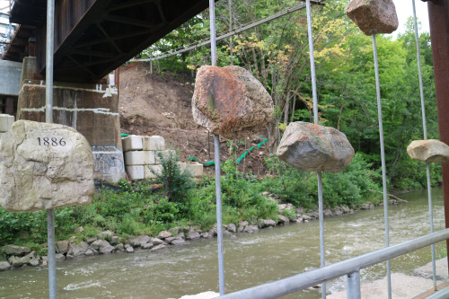
The first stone represents the great flood of 1886, a few months before the mouth of the Don River would be straightened as part of a project dubbed “The Don Improvement Project.” The project called for the straightening of the Don River south from Winchester Street as a way of diverting polluted waters into Ashbridges Bay marsh. When that proved unsuccessful, the mouth was turned 90 degrees where it would empty into the inner harbour.
To remedy the damage that was caused by this straightening, the Don Mouth Naturalization and Port Lands Flood Protection project was announced to transform the existing mouth of the Don River, including the Keating Channel, into a healthier, more naturalized river outlet to the lake. This project will also remove the risk of flooding to the 240 hectares of urban land to the east and south of the existing river.
[advanced_iframe securitykey=”b846dca6faa2d4c5cdfef39ad6176d03cf94a66b” use_shortcode_attributes_only=”true” src=”https://www.youtube.com/embed/GzAf7EIRlbU?rel=0″ frameborder=”0″ allowfullscreen=”true” content_styles=”width:100%” width=”100%” enable_responsive_iframe=”true” iframe_height_ratio=”0.5625″]
The final stone on the bridge is etched with the year 1998, commemorating a substantial flood that occurred that year; the same year that the Task Force to Bring Back the Don was initiated.
The stones (a symbolic representation of water levels and not the actual recorded water levels) are a reminder of the volatility of water levels in the Don. Due to the urbanized nature of the Don River watershed, the river experiences low base flow with high volume floods. That means the water levels of the Don River can rise very quickly with moderate to heavy rainfall.
The results of flooding can cause serious damage to property and the ecological health of the waterways and surrounding environment. TRCA Flood Risk Management works to reduce the risks caused by flooding by providing local agencies and the public with notice, information and advice so that they can respond during severe rainfall events with the potential for flooding and during flood related emergencies.
TRCA Flood Messages: What do they mean? #TRCAflood #floodmessages #floodwarning https://t.co/QTeGW0L8Yn pic.twitter.com/7S6QGFJ9aO
— TRCA Flood (@TRCA_Flood) August 22, 2016
Access to Robert Sprachman’s installation can be reached most directly via the access point into the Charles Sauriol Conservation Area located off of Wynford Heights Crescent.